
KENTUCKY — A violent overnight severe weather event swept across Kentucky, producing 8 to 9 tornado warnings and more than 20 severe thunderstorm warnings before the severe window finally closed at 4:25 a.m. ET — with East Kentucky taking a surprise damaging wind hit, Central and Northern Kentucky seeing concentrated tornado warning activity, and another round of dangerous storms already forecast to arrive in just 15 hours.
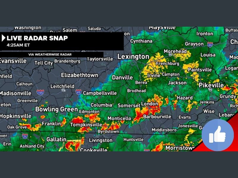
Severe Window Closes at 4:25 AM After Intense Night
Meteorologist George with Weather Now Kentucky confirmed at 4:25 a.m. ET that the overnight severe broadcast had concluded after an intense and wide-ranging severe weather event across the Commonwealth. The final tally — 8 or 9 tornado warnings and over 20 severe thunderstorm warnings — reflects how active and widespread the overnight storm system proved to be across multiple regions of the state.
Live radar at 4:25 a.m. showed residual storm activity still visible across East Kentucky, the Lexington corridor, and scattered cells pushing through southeastern portions of the state toward the Virginia and Tennessee border regions.
Surprise Damaging Wind Event Strikes East Kentucky
One of the most notable developments of the overnight event was an unexpected and significant damaging wind event that struck East Kentucky — an area that was not the primary focus of the evening’s forecast. Communities across the East Kentucky region including areas near Pikeville, Hazard, Jackson, Barbourville, and the surrounding mountain corridor absorbed damaging wind impacts that forecasters described as a surprise outcome of the night’s storm activity.
Damage assessment across East Kentucky will begin in the daylight hours as conditions allow crews to access affected areas.
Tornado Warnings Concentrated Over Central and Northern Kentucky
The tornado warning activity overnight was most heavily concentrated across Central Kentucky and Northern Kentucky. Multiple tornado warnings fired across this corridor during the evening and overnight hours, putting communities near Lexington, Danville, Frankfort, and surrounding areas under repeated warning issuances throughout the broadcast period.
Northern Kentucky also saw a couple of tornado warnings issued, extending the threat zone toward the Cincinnati metro border region.
West Kentucky Was an Obvious Bust
In contrast to the active night across Central, Northern, and East Kentucky, West Kentucky came in as what forecasters described as an obvious bust — the anticipated severe weather activity failed to materialize to the degree expected across the western portion of the state. Communities in the Paducah, Madisonville, Hopkinsville, and Bowling Green region saw significantly less activity than the overnight forecast had suggested.
Another Round of Storms Coming in Just 15 Hours
Despite the overnight severe window closing, Kentucky is not out of danger. Forecasters confirmed that another round of rowdy storms is expected to arrive in approximately 15 hours from the 4:25 a.m. update — placing the next storm threat squarely in the Monday afternoon and evening timeframe.
Residents across all regions of Kentucky — particularly those in Central, Northern, and East Kentucky who already experienced impacts overnight — should use the morning hours to assess any damage, ensure their weather alert systems are functioning, and be fully prepared for the next round of severe weather arriving later today. Stay with GordonRamsayClub.com for the latest updates.

Leave a Reply