
NORTH TEXAS / EAST TEXAS — Forecasters have issued a significant hail risk upgrade for North Texas on Tuesday, with softball-size hail now possible during the afternoon and evening hours with the strongest storms that develop — placing a massive corridor of communities from the Dallas-Fort Worth area through East Texas and into the Shreveport Louisiana region under a serious large hail threat.
Hail Risk Upgraded to Softball Size Tuesday
The hail threat for Tuesday has been dramatically upgraded from the previously mentioned 2-inch maximum. Forecasters are now warning that softball-size hail — approximately 4 to 4.5 inches in diameter — is possible with the strongest storms forming across North Texas during Tuesday afternoon and evening hours.
Softball-size hail is among the most destructive hail categories possible, capable of instantly totaling vehicles, punching through roofing materials, shattering windows, and causing serious injury or death to anyone caught outdoors during impact. This is an extreme hail threat that demands immediate preparation across the entire warned zone.
Primary Hatched Hail Zone Covers Massive North and East Texas Corridor
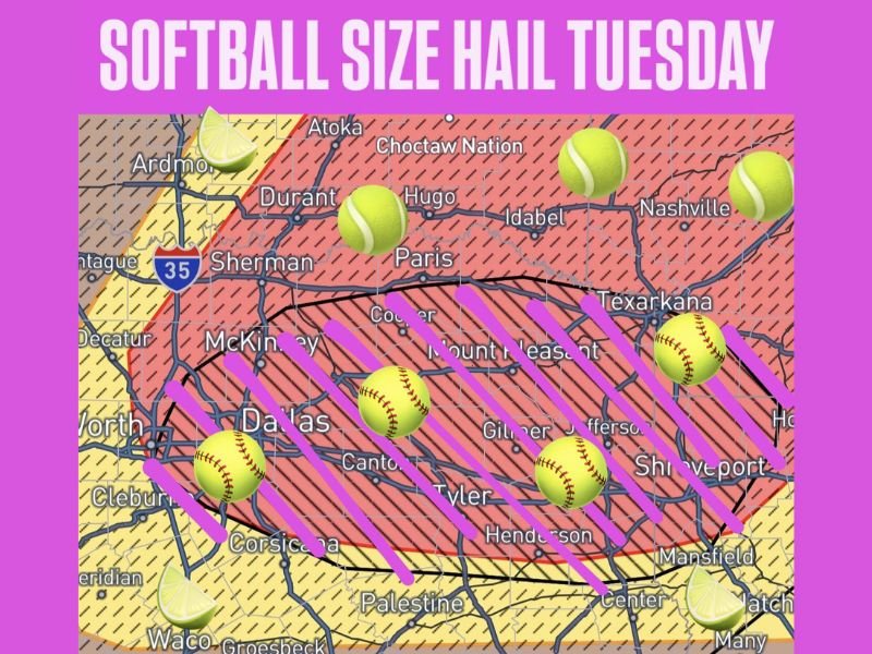
The core hatched hail risk zone shown on Tuesday’s outlook maps covers an enormous swath of North and East Texas — with the highest probability corridor running through a dense band of major communities including Dallas, McKinney, Sherman, Paris, Mount Pleasant, Canton, Tyler, Gilmer, Jefferson, Texarkana, and Shreveport on the Louisiana side of the border.
Softball-size hail icons are placed directly over Dallas, the area east of Fort Worth, and multiple East Texas communities — underscoring that the most extreme hail potential is focused on this central corridor stretching from the DFW metro all the way to the Texas-Louisiana border region.
Tennis Ball and Lime Size Hail in Surrounding Zones
Outside the core softball-size corridor, the broader hail risk map shows tennis ball-size hail — approximately 2.5 inches — possible across surrounding areas including Sherman, Durant, Hugo, and communities in southern Oklahoma north of the primary zone. Lime-size hail indicators appear across the outer edges of the risk area including near Ardmore, Waco, and communities along the southern and western fringe zones.
The gradient from lime to tennis ball to softball clearly identifies the Dallas through East Texas corridor as the most dangerous zone for catastrophic hail damage on Tuesday.
Fort Worth Waco and Western Communities on Southern Edge
Fort Worth, Cleburne, Corsicana, Waco, and Palestine sit along the southern and western edge of the hail risk zone — showing lime-size hail potential with lower but real probability of larger stones if storm cells track across those areas during the Tuesday evening window.
Protect Vehicles and Property Before Tuesday Afternoon
With softball-size hail now in the forecast, residents across the entire North and East Texas corridor should take immediate protective action before Tuesday afternoon arrives. Move all vehicles into garages or covered parking — a single softball-size hailstone can total an unprotected vehicle in seconds. Secure or bring in all outdoor furniture, equipment, and property that could be damaged or turned into projectiles by large falling hail.
Do not be outdoors in any capacity when storms begin firing Tuesday afternoon and evening across this corridor. Stay with GordonRamsayClub.com for the latest updates.

Leave a Reply