
PADUCAH, KENTUCKY — A line of showers and storms was heading toward the Kentucky and Tennessee area from the west as of 5:30 AM Friday, though forecasters noted the system would be weakening as it moved through the morning hours. Southeast Missouri and Southern Illinois were expected to pick up the most rainfall from the system at 0.25 to 0.50 inches, while amounts would taper down quickly over Kentucky and Tennessee where totals of anything more than 0.1 inches would be considered lucky.
Weakening Storm Line Approaching From the West at 5:30 AM — Rain Amounts Tapering Quickly
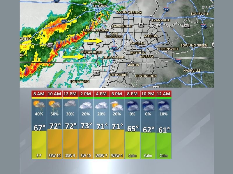
Radar at 5:30 AM showed the line of showers and storms still fairly well organized as it pushed eastward from the St. Louis and Fredericktown corridor toward Cape Girardeau, Poplar Bluff, and New Madrid. Yellow directional arrows on the radar indicated the system tracking directly toward the Paducah and western Kentucky zone, with the line expected to continue weakening progressively as it moved away from its source region and into the Kentucky and Tennessee coverage area through the morning hours.
Southeast Missouri communities including Cape Girardeau, Carbondale, and the broader SEMO region were in line to receive the most meaningful rainfall from the system before it weakened further east.
Kentucky and Tennessee to See Minimal Rain — Under 0.1 Inch for Most Areas
Forecasters were clear that Kentucky and Tennessee residents should not expect significant rainfall from the incoming system. Rain totals across Kentucky and Tennessee were expected to taper down quickly as the weakening line pushed through, with amounts likely staying under 0.1 inches for most communities and potentially even less depending on exactly how quickly the system lost its remaining organization.
The Paducah, Mayfield, Murray, Hopkinsville, Bowling Green, and broader western Kentucky zone sat in the path of the weakening line as it tracked eastward through the morning hours of Friday.
Hour-By-Hour Forecast Shows 50 Percent Rain Chance at 10 AM Dropping to Zero by Evening
The hour-by-hour forecast for the area showed the highest rain chances concentrated in the morning hours, with 40 percent at 8 AM rising to 50 percent by 10 AM before dropping to 30 percent at noon and fading to 20 percent through the afternoon. Rain chances reached zero by 8 PM as the system cleared and calmer and drier conditions settled in through the overnight hours with temperatures dropping from 73 degrees in the afternoon to 61 degrees by midnight. Stay with GordonRamsayClub.com for the latest weather updates and detailed forecast coverage.
Leave a Reply