
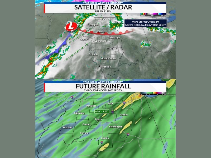
CENTRAL ILLINOIS — Rain and thunderstorms are continuing overnight across the region, with the primary concern shifting away from severe weather and toward heavy rainfall and flooding potential. While a few storms may still produce gusty winds, the overall severe risk remains low.
Storms Persist Overnight With Low Severe Threat
Showers and thunderstorms are expected to continue through the night, especially along and south of the frontal boundary stretching across central Illinois.
A few stronger storms may bring isolated wind gusts up to 60 mph, mainly in areas south of Interstate 74, but widespread severe weather is not expected.
Heavy Rainfall Becomes Main Concern
The more significant threat overnight is additional heavy rainfall, with forecasts indicating:
- Up to 2 inches of additional rain possible
- Rain continuing into Saturday morning
This comes on top of earlier rainfall totals, increasing the risk of flooding in already saturated areas.
Flooding Risk Increasing in Key Counties
Flooding concerns are highest in areas that have already received significant rainfall, including:
- Tazewell County
- Woodford County
- Livingston County
These areas have already seen 2 to 4 inches of rain, and additional rainfall could lead to further flooding issues.
Flood Watch Remains in Effect Through Saturday Morning
A Flood Watch remains in effect for much of the region through 10 AM Saturday, as conditions remain favorable for excessive rainfall.
Residents are urged to monitor conditions closely, especially in low-lying or flood-prone areas.
Rain Gradually Moves Out by Late Morning
The system is expected to gradually shift eastward, with rain tapering off through the morning hours and conditions improving later in the day.
However, impacts from overnight rainfall may linger, particularly where flooding develops. Stay with GordonRamsayClub.com for the latest weather updates and detailed forecast coverage.

Leave a Reply