
EASTERN IOWA, NORTHERN ILLINOIS, SOUTHERN WISCONSIN — A developing severe weather setup is raising concern for fast-moving, long-track tornadoes expected to impact parts of eastern Iowa, northern Illinois, and southern Wisconsin on Thursday. Forecast data indicates storm motions exceeding 50 mph, significantly reducing warning time and increasing the risk level across the region.
Fast Storm Motion Reducing Reaction Time
The primary concern with this system is storm speed. With thunderstorms expected to move rapidly northeast, communities may have very little time to react once warnings are issued. This type of setup is particularly dangerous because it limits the effectiveness of traditional warning systems.
Meteorological analysis highlights that fast-moving supercells could develop quickly and intensify just as rapidly, making conditions highly unpredictable.
Tornado Risk Focused in Key Midwest Corridor
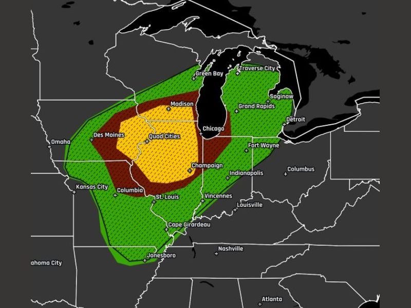
The highest tornado probabilities are centered from Des Moines through the Quad Cities into areas near Chicago, extending toward southern Wisconsin. Within this zone:
- A 10% tornado probability area indicates a heightened risk of tornado development
- Surrounding regions fall under 5% and 2% risk zones, still capable of producing isolated tornadoes
- There is also a signal for EF2+ tornado potential, suggesting stronger, more damaging tornadoes cannot be ruled out
Cities including Madison, Chicago, Champaign, and surrounding areas are within or near the higher-risk zones.
Conditions Support Strong Tornado Development
This setup is being driven by a combination of:
- Strong atmospheric instability
- Favorable wind shear for rotating storms
- Rapid storm organization potential
These ingredients together create an environment where long-track tornadoes — capable of staying on the ground for extended distances — may form.
A Day That Requires Close Monitoring
Forecast guidance clearly indicates that this is not a routine severe weather day. The combination of speed, strength, and limited warning time makes this situation more dangerous than typical storm events.
Residents across the affected areas are advised to:
- Stay alert to weather updates throughout the day
- Have multiple ways to receive warnings
- Be prepared to act immediately if a warning is issued
Stay with GordonRamsayClub.com for the latest weather updates and detailed forecast coverage.

Leave a Reply