
OMAHA, NEBRASKA — The European Centre for Medium-Range Weather Forecasts is issuing a serious wake-up call for the central plains Tuesday, with the 00z ECMWF run painting one of the most extreme instability signatures seen this season directly over eastern Nebraska and western iowa.
CAPE Values at the Upper End of the Spectrum
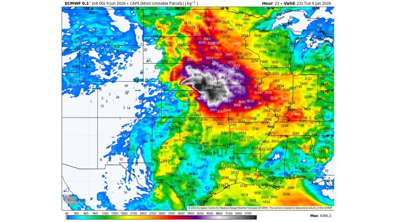
The model’s Most Unstable CAPE output valid at 23z Tuesday shows a black-and-white bullseye core reaching 6,366 J/kg centered over the eastern Nebraska and western Iowa corridor. Values in that core range between 5,000 and 6,200-plus J/kg — levels meteorologists describe as among the most charged atmospheric setups possible.
Surrounding that core, purple shading indicating 4,000 to 5,000 J/kg wraps broadly across Iowa, eastern Nebraska, and extends into northern Missouri and Kansas. Red shading in the 3,000 to 4,000 J/kg range sprawls further across the central and northern plains, covering Missouri, the Dakotas, and into Minnesota.
What These Numbers Actually Mean
For context, CAPE readings above 4,000 J/kg are widely considered threshold values for explosive convective development. At 6,000 J/kg and beyond, the fuel available for storm growth reaches a tier that demands serious attention from forecasters and the public alike.
That level of instability alone does not guarantee severe weather. Wind shear and a triggering mechanism must be present. But when adequate shear and forcing pair with CAPE in this range, the potential for intense supercells, large hail, damaging winds, and tornadoes rises dramatically.
Western Corn Belt on Watch
The western Corn Belt sits directly in the crosshairs of this setup. Agricultural interests across eastern Nebraska and Iowa need to monitor Tuesday’s convective potential closely. Heavy rainfall, large hail, and damaging wind gusts are all on the table if storm initiation occurs within this instability envelope.
Forecasters will be watching afternoon and evening hours closely as surface heating maximizes instability ahead of any approaching forcing. This is a loaded atmosphere that warrants close monitoring through the day.
Stay with GordonRamsayClub.com for the latest updates.

Leave a Reply