
NORTH CAROLINA — Easter Sunday across North Carolina is shaping up to be far more active than a typical spring holiday, as a cold front pushes through the state bringing increasing clouds, scattered showers, and the potential for a few stronger storms later in the day.
While the day begins relatively calm in some areas, conditions are expected to steadily deteriorate from west to east, with rain and storms expanding across the state through the afternoon and evening hours.
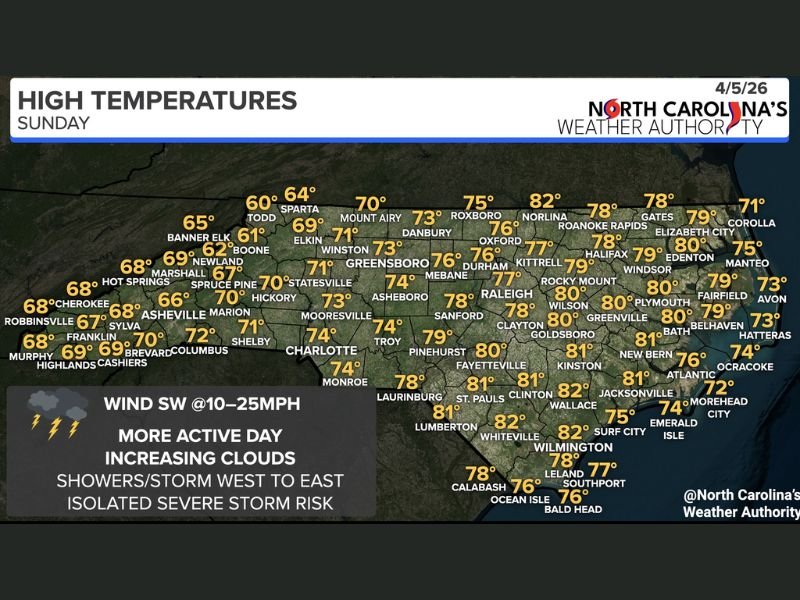
Morning Showers Begin in Mountains and Foothills
The first signs of this changing weather pattern are already developing across western North Carolina, where showers are moving through the mountains and foothills early in the day. Some of these initial rain bands could bring brief heavier bursts, especially during the morning hours.
These showers are tied to a cold front advancing from the west, which will act as the main driver of today’s unsettled weather.
Storms Spread East Into Central and Eastern North Carolina
As the day progresses, the system will push eastward, carrying showers and thunderstorms into central North Carolina by late morning into the afternoon, including areas like Greensboro, Raleigh, and surrounding communities.
By the late afternoon and evening, the activity is expected to reach eastern parts of the state, including Greenville, New Bern, and coastal areas. This west-to-east progression means some areas may see multiple rounds of rain, especially as the front continues to move through.
Gusty Winds and Isolated Strong Storms Possible
Although widespread severe weather is not expected, there is still a limited risk of a few stronger storms, particularly during the afternoon and early evening.
The main concern with any stronger storms will be gusty winds, which could briefly reach levels capable of causing minor impacts. However, forecasters are not anticipating a large-scale severe weather outbreak.
Residents are still advised to remain aware of changing conditions, especially if outdoor Easter plans are scheduled later in the day.
Temperatures Vary Across the State
Temperatures will also reflect the influence of the incoming system, with a noticeable difference between western and eastern North Carolina:
- Western NC (Mountains/Foothills): Cooler conditions with highs in the 60s to low 70s
- Central NC: Mid to upper 70s expected
- Eastern NC: Warmer conditions, reaching the upper 70s to low 80s
Despite the warmth in eastern areas, increasing cloud cover and incoming storms will limit how high temperatures can climb.
Breezy Conditions Add to the Active Feel
Winds will be another factor throughout the day, with southwest winds ranging from 10 to 25 mph, adding to the overall unsettled feel of the weather. These breezes will help fuel storm development while also making conditions feel more dynamic compared to recent calmer days.
A Changing Easter With Weather Moving Through
Overall, Easter Sunday across North Carolina will be defined by increasing clouds, spreading showers, and periods of gusty winds, with rain moving steadily from the mountains to the coast.
While not a washout for everyone at all times, the timing of the storms means many areas will experience at least some rain during the day.
Residents are encouraged to stay updated and plan accordingly, especially for outdoor activities, as this active weather pattern continues to move across the state.

Leave a Reply