
BALTIMORE, MARYLAND — Wednesday’s tornado outbreak across Illinois and Indiana may actually work in Baltimore’s favor Thursday, as forecasters are watching whether the remnant storm activity tracking east overnight could produce morning rain showers across Maryland that stabilize the atmosphere and reduce the threat for strong afternoon storms across the Baltimore metro Thursday.
SPC Day 1 Outlook Shows Moderate Risk Centered on Illinois and Indiana
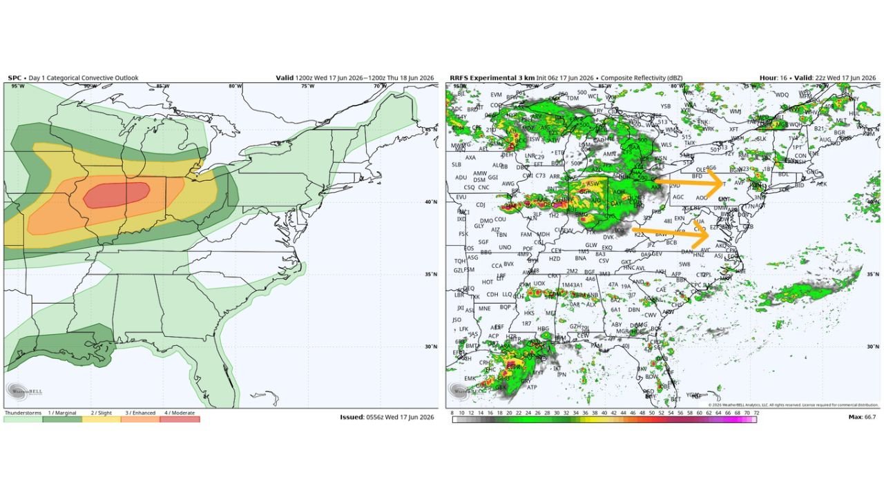
The SPC Day 1 categorical convective outlook issued 05562 Wed June 17 valid through 1200z Thursday June 18 shows a Level 4 Moderate Risk in red centered over central Illinois and Indiana, with Enhanced Risk in orange surrounding the core across the broader Midwest corridor. A Slight Risk in yellow extends the severe weather footprint eastward toward Ohio and western Pennsylvania, with Marginal Risk shading covering portions of the mid-Atlantic including Maryland.
The storm system is clearly focused on Illinois and Indiana for Wednesday, with energy progressively weakening as it spreads eastward.
RRFS Model Shows Storm Remnants Tracking Into Mid-Atlantic by Wednesday Evening
The RRFS Experimental 3km composite reflectivity valid at 22z Wednesday June 17 shows orange arrows indicating the eastward track of storm remnants moving toward the mid-Atlantic corridor. The model shows moderate radar returns over Ohio and Pennsylvania tracking toward the Baltimore and Washington region during the late evening and overnight hours.
If those remnants arrive as rain showers Thursday morning, the stabilizing effect on the atmosphere could meaningfully reduce afternoon storm fuel across the Baltimore metro.
Baltimore Metro Thursday Afternoon Storm Potential Remains Uncertain
The key question for Thursday in Maryland is whether morning clouds and rain from the departing Midwest storm system will be enough to stabilize the atmosphere ahead of any afternoon heating. If stabilization occurs, the threat for strong storms across the Baltimore metro Thursday afternoon would be reduced compared to earlier forecasts.
Forecasters are watching this interaction closely as Wednesday’s Midwest outbreak evolves and remnants push east through the overnight hours toward Maryland.
Stay with GordonRamsayClub.com for the latest updates.

Leave a Reply