
CHICAGO, ILLINOIS — A cluster of thunderstorms is set to push through the Midwest and Ohio Valley Thursday evening, bringing all severe hazards to a densely populated corridor stretching from eastern Iowa and Illinois through Indiana and into Ohio.
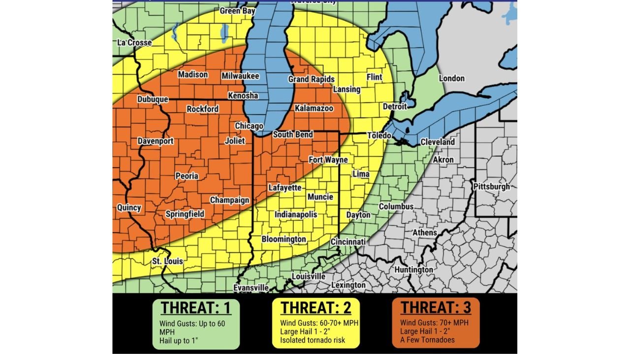
Threat 3 Zone Carries the Highest Risk Thursday Evening
The highest risk area Thursday evening falls across a Threat 3 corridor covering Chicago, Joliet, Rockford, Madison, Milwaukee, Kenosha, Dubuque, Davenport, Peoria, and Champaign. Wind gusts exceeding 70 mph, large hail up to 1 to 2 inches, and a few tornadoes are all possible within this orange-shaded zone during the evening hours.
Damaging wind gusts are identified as the primary concern for this event, with the storm cluster expected to produce widespread wind damage potential across the affected region.
Threat 2 Zone Extends Risk Into Indiana and Ohio
A Threat 2 zone in yellow surrounds the highest risk area, covering South Bend, Fort Wayne, Lafayette, Indianapolis, Muncie, Dayton, Cincinnati, Columbus, Kalamazoo, Grand Rapids, Lansing, and Toledo. Wind gusts of 60 to 70 mph, large hail up to 1 to 2 inches, and an isolated tornado risk are all on the table across this broader corridor Thursday evening.
The combination of damaging winds and hail makes this a significant severe weather event well beyond just the Threat 3 core.
Threat 1 Zone Covers Outer Fringe Including St. Louis and Louisville
A Threat 1 zone extends the wind and hail risk further outward, covering St. Louis, Springfield, Quincy, Evansville, Louisville, Lexington, Lima, Akron, Cleveland, and Bloomington. Wind gusts up to 60 mph and hail up to 1 inch are possible across this outer zone as the storm cluster moves through Thursday evening.
Residents across all three threat zones should have a severe weather plan ready ahead of Thursday evening and monitor local watches and warnings as the storm system approaches.
Stay with GordonRamsayClub.com for the latest updates.

Leave a Reply