
BISMARCK, NORTH DAKOTA — A potentially significant and robust severe weather episode is taking shape for the Northern Plains and Upper Midwest for Day 5 Tuesday June 9 and Day 6 Wednesday June 10, 2026, as a high-amplitude trough moves into the region bringing all severe hazards including the potential for significant severe weather across North Dakota, South Dakota, Minnesota, and surrounding areas on both days.
High Amplitude Trough Moving Into Northern Plains Tuesday and Wednesday with All Hazards Possible
Forecasters are flagging a robust severe weather setup developing across the Northern Plains and Upper Midwest for Tuesday and Wednesday June 9 to 10, 2026, as a high-amplitude trough pushes into the region from the northwest. All severe weather hazards appear possible on both days including large hail, damaging winds, and tornadoes, with the potential for significant severe weather explicitly noted across the Northern Plains corridor. The overall atmospheric setup is described as generally favorable for a robust episode of severe weather despite some uncertainties remaining regarding the precise timing of the trough and the degree of moisture return into the region ahead of the system.
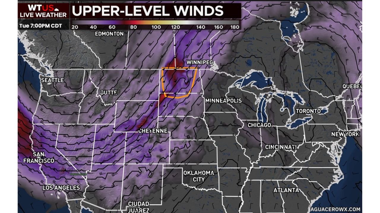
Upper Level Wind Analysis Shows 120 to 140 Knot Jet Stream Core Near Winnipeg and Bismarck Corridor
WTUS Live Weather upper level wind analysis valid Tuesday 7:00 PM CDT shows an extraordinarily powerful jet stream core with wind speeds of 120 to 140 knots indicated in the deep purple and dark red shading concentrated in an orange-outlined zone near the Winnipeg and North Dakota border corridor. This intense upper level wind energy ejecting southeastward across the Northern Plains will provide the dynamic forcing necessary to support explosive storm development and severe weather organization across the region during the Tuesday and Wednesday timeframe. Wind speeds of this magnitude in the upper atmosphere are a key ingredient for supporting supercell development and significant severe weather potential.
Timing and Moisture Return Uncertainties Remain But Setup Appears Favorable
Some forecast uncertainties remain at this range regarding the precise timing of the trough passage and upper level flow across the Northern Plains, as well as the degree of low-level moisture return that will be available ahead of the system. However forecasters are emphasizing that despite these uncertainties, the overall setup does appear generally favorable for a robust and significant severe weather episode across the Northern Plains and Upper Midwest on both Tuesday and Wednesday June 9 to 10.
Northern Plains and Upper Midwest Residents Should Begin Monitoring for Next Week
With a potentially significant two-day severe weather episode targeting the Northern Plains and Upper Midwest for Tuesday and Wednesday June 9 to 10, 2026, residents across North Dakota, South Dakota, Minnesota, and surrounding areas should begin closely monitoring updated NWS and SPC outlooks over the weekend as forecast confidence continues to build heading into next week.
Stay with GordonRamsayClub.com for the latest updates.

Leave a Reply