
KANSAS CITY, MISSOURI — An unusual and highly volatile severe weather setup is developing along the Kansas-Nebraska and Missouri-Iowa border region on Friday June 5, 2026, as AguaceroWX instability graphics show extreme storm fuel concentrated along a boundary stretching from northwest Kansas through Marysville and Falls City toward the Missouri-Iowa border, with storms forced to initiate purely through surface heating rather than upper-air disturbance support given the nearest disturbances sit 450 to 600 miles away.
Extreme Instability Concentrated Along Kansas-Nebraska and Missouri-Iowa Border Boundary
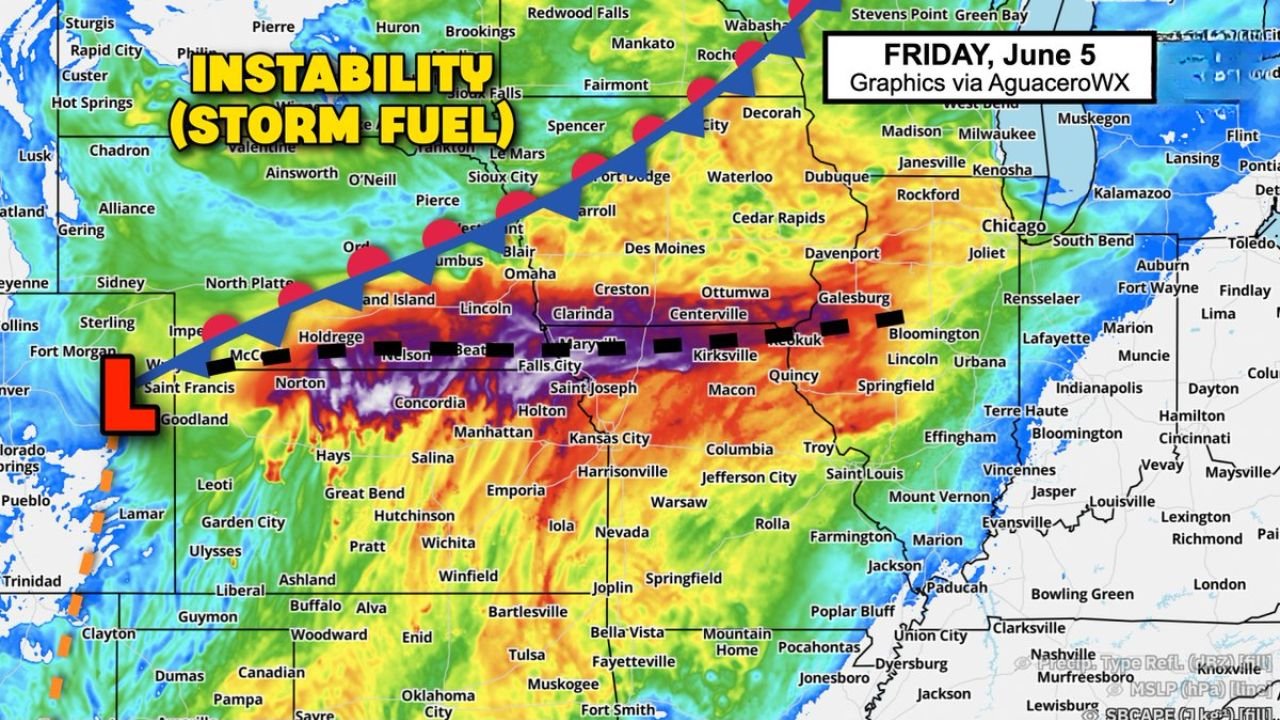
AguaceroWX instability graphics for Friday June 5, 2026 show an extraordinarily concentrated zone of extreme storm fuel in deep purple and dark red CAPE values running along a boundary from northwest Kansas near Norton, Concordia, and Manhattan northeastward through Marysville, Falls City, Saint Joseph, and toward the Missouri-Iowa border near Clarinda, Centerville, and Kirksville. The instability corridor is sharply defined and intensely concentrated, with deep purple values indicating some of the highest CAPE readings possible sitting directly along the boundary where storm initiation is most likely to occur during the late afternoon heating hours.
Nearest Upper Air Disturbances Sitting 450 to 600 Miles Away Forcing Surface Heating Initiation
WeatherBell graphics for Friday June 5 illustrate a critical dynamic of today’s severe weather setup, showing the nearest upper-air disturbances located approximately 600 miles to the northwest over the Pacific Northwest and approximately 450 miles to the south over Texas and the Gulf Coast. With no nearby upper-level support available to trigger storm development, storms across the Kansas-Nebraska and Missouri-Iowa border region will be forced to initiate solely through surface air heating during the late afternoon hours. This means storms will form late in the day as surface temperatures peak and the air becomes buoyant enough to rise on its own into the explosive instability overhead.
Late Day Storm Formation Expected Along the Boundary as Surface Air Heats Sufficiently
The combination of extreme instability along the boundary and the complete absence of upper-air disturbance support means today’s storm initiation will be almost entirely dependent on afternoon surface heating reaching a critical threshold. Storms are expected to form late in the day across the Kansas-Nebraska and Missouri-Iowa border corridor as the surface air heats sufficiently to rise through the capping layer into the extreme instability above. Once storms initiate in this environment, rapid intensification and severe weather development are expected given the extraordinary storm fuel in place along the boundary.
Kansas, Nebraska, Missouri, and Iowa Border Residents Should Be Ready for Evening Storms
With explosive instability loaded along the Kansas-Nebraska and Missouri-Iowa border boundary and late day storm initiation expected Friday June 5, 2026, residents across Norton, Concordia, Marysville, Falls City, Saint Joseph, Clarinda, and surrounding border communities should be fully prepared with active weather alerts and shelter plans ready before the late afternoon and evening storm development window arrives.
Stay with GordonRamsayClub.com for the latest updates.

Leave a Reply