
MIAMI, FLORIDA — A weak but notable tropical weather signal is emerging over the Gulf of Mexico for around mid-June 2026, as ECMWF ensemble data initialized 00Z June 5, 2026 and valid Days 0 through 15 shows tropical depression probability values of 40 to 70 percent concentrated over the Gulf basin, while forecasters emphasize that poor model agreement and consistency across the broader guidance set keeps formal tropical cyclone concern low at this time.
ECMWF Shows 40 to 70 Percent Tropical Depression Probability Over Gulf for Mid-June
The ECMWF 0.25 degree ensemble tropical depression probability map valid through June 20, 2026 shows a meaningful but uncertain signal over the Gulf of Mexico, with purple and blue probability shading covering the Gulf basin and extending across Gulf Coast states from Texas through Florida and into the Southeast. Core probability values of 40 to 70 percent are indicated over portions of the central and eastern Gulf, while the broader surrounding area from the Gulf Coast northward through the Southeast and Mid-Atlantic shows elevated but lower probability values in the 20 to 50 percent range suggesting the potential moisture and rain impacts could extend well inland if any development occurs.
Poor Model Agreement Keeping Formal Tropical Cyclone Concern Low at This Time
Despite the ECMWF tropical depression signal, forecasters are specifically noting that poor agreement and consistency amongst the broader global model guidance set is keeping formal tropical cyclone concern at a low level for the mid-June Gulf timeframe. The upper right panel showing ensemble member clustering indicates some spread and disagreement in the model solutions for the potential Gulf system, with a 978 millibar low pressure center appearing in some ensemble members but lacking consistent support across the full guidance suite. Until model agreement improves significantly, the tropical signal should be treated as a monitoring situation rather than an imminent threat.
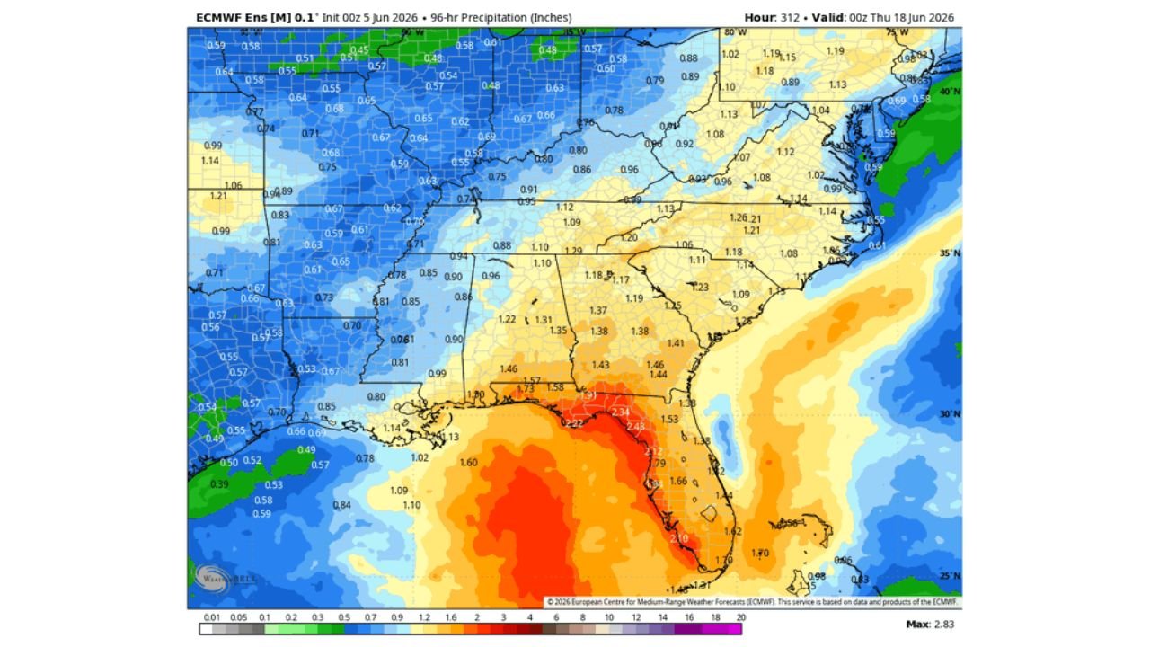
Rain Chances May Increase Along Gulf Coast and Southeast if Weak Development Occurs
Even without formal tropical cyclone development, forecasters note that rain chances may increase along parts of the Gulf Coast and Southeast should at least weak development occur in the Gulf around mid-June. The precipitation probability map shows elevated rainfall values across Florida and the Southeast corridor in the 1.00 to 1.60 inch range for portions of the region during this timeframe, indicating that moisture associated with any Gulf disturbance could produce enhanced rainfall across coastal areas regardless of whether formal tropical organization occurs.
Texas, Louisiana, Mississippi, Alabama, and Florida Residents Should Monitor NHC Closely
With a weak but present tropical signal in the Gulf for mid-June and rainfall implications possible across Texas, Louisiana, Mississippi, Alabama, and Florida, Gulf Coast residents are encouraged to stay connected to official National Hurricane Center tropical weather outlooks over the coming week as forecasters continue to evaluate whether the mid-June Gulf signal gains consistency and support across the broader model guidance suite.
Stay with GordonRamsayClub.com for the latest updates.

Leave a Reply