
MIAMI, FLORIDA — The Atlantic basin remains quiet for the next seven days with no tropical cyclone activity expected according to the National Hurricane Center Seven-Day Graphical Tropical Weather Outlook, but global models are continuing to hint at a potential tropical system developing over the Gulf of Mexico in the 10 to 15 day timeframe, with European ensemble data placing the probability of tropical storm formation in mid-June at 20 to 30 percent.
NHC Confirms No Tropical Cyclone Activity Expected Across Atlantic Basin Next 7 Days
The National Hurricane Center Seven-Day Graphical Tropical Weather Outlook clearly shows tropical cyclone activity is not expected during the next 7 days across the entire Atlantic basin including the Gulf of Mexico, Caribbean Sea, and open Atlantic. The outlook map shows no areas of concern and no development markers across any portion of the monitored basin through the seven-day window, providing a quiet near-term tropical weather period for all Gulf Coast and Atlantic coastal communities.
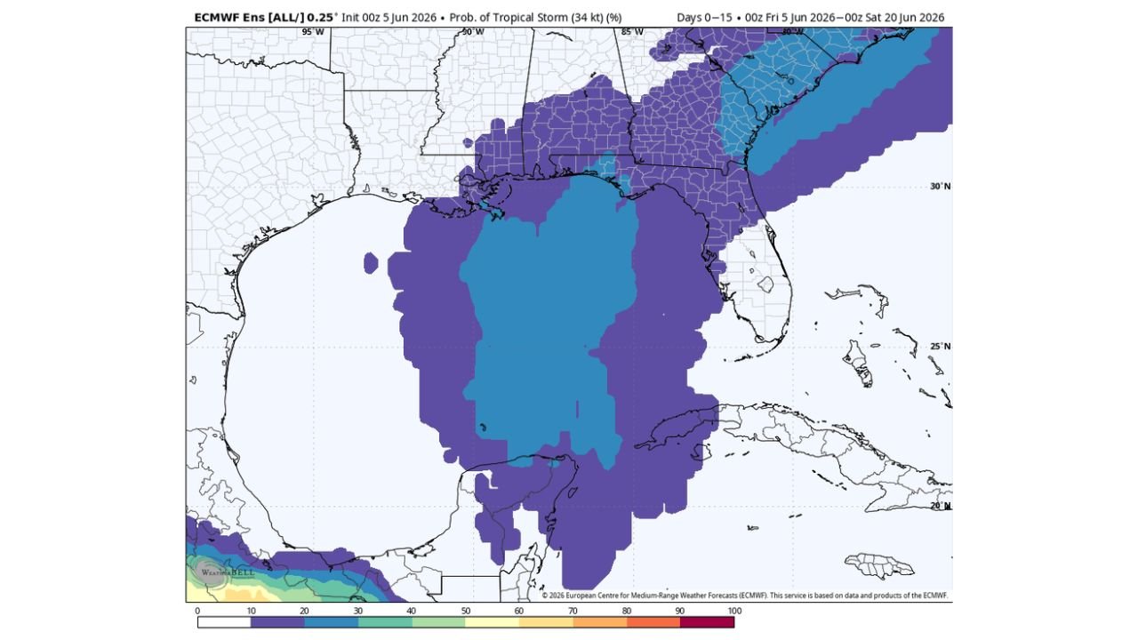
ECMWF European Ensemble Showing 20 to 30 Percent Tropical Storm Probability in Mid-June Gulf
Beyond the quiet seven-day window, the European Centre for Medium-Range Weather Forecasts ensemble model initialized 00Z June 5, 2026 shows a meaningful tropical storm formation probability signal over the Gulf of Mexico for the 10 to 15 day timeframe. The ECMWF probability map valid Days 0 through 15 shows blue and purple shading covering the Gulf of Mexico and extending across Gulf Coast states from Texas through Florida and into the Southeast, with probability values in the 20 to 50 percent range across the core Gulf region. European ensemble output places the overall probability of tropical storm formation in the Gulf during mid-June at 20 to 30 percent.
Early Season Gulf Tropical Systems Typically Rain-Makers Rather Than Dangerous Hurricanes
Forecasters are providing important context for the mid-June Gulf tropical signal, noting that most early season tropical systems that form in the Gulf of Mexico are primarily rain-makers rather than dangerous hurricanes. Wind shear and dry air that characterize the early June atmospheric environment typically limit the intensity and organizational potential of any tropical feature that develops during this timeframe. The 20 to 30 percent formation probability also reflects the significant uncertainty inherent in forecasting tropical development beyond the seven-day window where no meaningful forecast skill exists for placement and intensity.
Gulf Coast Residents Should Monitor Official NHC Forecasts as Mid-June Approaches
While the immediate tropical weather outlook remains quiet, Gulf Coast residents from Texas through Florida should begin monitoring official National Hurricane Center tropical weather outlooks more closely as the mid-June timeframe approaches and forecasters assess whether the potential Gulf system signal in the European ensemble continues to gain support from other global models.
Stay with GordonRamsayClub.com for the latest updates.

Leave a Reply