
ORLANDO, FLORIDA — A frontal line is helping trigger storm development across Florida and the broader Gulf South region on Tuesday June 2, 2026, with the SPC placing Florida under a Marginal Risk Level 1 of 5 and the Florida east coast identified as the area likely to see the most active and strongest storm coverage throughout the day.
SPC Marginal Risk Covers Florida Peninsula with East Coast Seeing Strongest Action
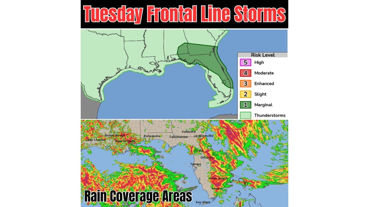
The SPC severe weather outlook shows a Marginal Risk zone concentrated across the Florida peninsula, with the darkest green shading indicating the areas most likely to see the strongest storms focused along and near the Florida east coast. Sea breeze interactions along the Atlantic coastline are serving as a primary focusing mechanism for the most intense storm coverage today, with the frontal line providing additional lift and instability to fire storms across the broader peninsula. Coverage elsewhere across the Gulf South remains more scattered and isolated in nature.
Frontal Line Triggering Widespread Rain and Storm Coverage From Gulf Coast to Florida
Rain coverage area graphics show extensive and heavy precipitation coverage stretching from the Louisiana Gulf Coast near Baton Rouge, New Orleans, and Lake Charles eastward through Pensacola, Tallahassee, Jacksonville, and down through the entire Florida peninsula including Ocala, Orlando, Tampa, Palm Beach, Miami, and Key West. The radar-indicated rain coverage shows intense precipitation cores concentrated particularly along the Florida east coast corridor and across South Florida, consistent with the SPC outlook highlighting this zone as the primary area of concern for strongest storm activity today.
Sea Breeze Locations Along Florida East Coast the Primary Focus for Strongest Storms
Forecasters are specifically highlighting sea breeze locations as the primary geographic focusing mechanism for the strongest storm coverage today across Florida. The combination of the approaching frontal boundary, abundant low-level moisture, and sea breeze convergence along the Atlantic coast creates a particularly favorable environment for storm initiation and intensification from Jacksonville southward through Palm Beach and Miami throughout the Tuesday afternoon hours.
Florida Residents From Jacksonville Through Miami Should Prepare for Active Afternoon
With the frontal line actively firing storms and sea breeze convergence targeting the east coast, Florida residents from Jacksonville through Daytona, Orlando, Palm Beach, and Miami should anticipate an active and potentially stormy afternoon and evening on Tuesday June 2, 2026. Staying connected to updated local forecasts throughout the day is strongly recommended across the entire Florida peninsula.
Stay with GordonRamsayClub.com for the latest updates.

Leave a Reply