
BISMARCK, NORTH DAKOTA — The Storm Prediction Center has outlined a Slight Risk Level 2 of 5 across the Dakotas, eastern Wyoming, and western Nebraska for today June 2, 2026, as a cold front draped across western North Dakota into eastern Wyoming makes slow eastward progress and combines with enhanced upper-level flow to initiate a dangerous storm complex this afternoon.
SPC Issues Slight Risk Across Dakotas, Eastern Wyoming, and Western Nebraska
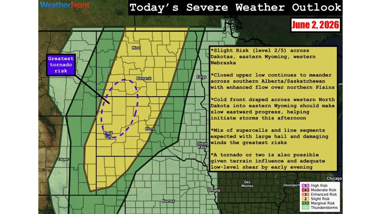
The WeatherFront Severe Weather Outlook for June 2, 2026 shows a well-defined Slight Risk zone covering a broad corridor from Minot and Bismarck in North Dakota southward through Pierre, Rapid City, and toward Sioux Falls in South Dakota and into western Nebraska. A surrounding Marginal Risk area extends the broader threat eastward toward Fargo, Des Moines, and Omaha. The outlook is driven by a closed upper low meandering across southern Alberta and Saskatchewan, producing enhanced flow across the northern Plains that will work in combination with the slow-moving cold front to fire storms during the afternoon hours.
Mix of Supercells and Line Segments Expected with Large Hail and Damaging Winds
Forecasters are expecting a mix of supercells and line segments to develop across the Slight Risk zone this afternoon, with large hail and damaging winds identified as the greatest hazards from this system. The combination of enhanced low-level shear and terrain influence across the region creates a favorable environment for organized and intense storm structures to develop and persist through the afternoon and into the early evening hours across the Dakotas and surrounding areas.
Greatest Tornado Risk Highlighted Near Rapid City and Western South Dakota
The WeatherFront outlook specifically highlights the greatest tornado risk in a zone near Rapid City and western South Dakota, indicated by a dashed purple circle on the map. A tornado or two is considered possible given adequate low-level shear developing by early evening combined with terrain influence across this portion of the risk area. While tornadoes are not the primary threat, residents in and around the Rapid City corridor should treat this risk seriously as storm mode evolves through the afternoon.
Residents Across the Dakotas and Western Nebraska Should Act Now
With supercells, large hail, damaging winds, and isolated tornadoes all possible across the Slight Risk zone today, residents from Bismarck and Minot through Pierre, Rapid City, and Sioux Falls should prepare now ahead of storm initiation this afternoon. Staying connected to local National Weather Service updates throughout the day is strongly recommended.
Stay with GordonRamsayClub.com for the latest updates.

Leave a Reply