
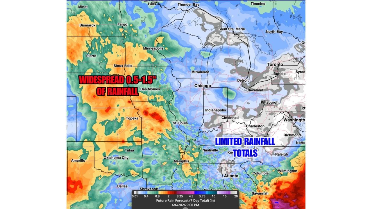
TOPEKA, KANSAS — A more active rainfall pattern is setting up across the Central Plains for next week, with BAM Weather’s Future Rainfall Totals forecast through June 6, 2026 showing widespread accumulations of 0.5 to 1.5 inches across a broad zone stretching from Sioux Falls and Des Moines in the north through Topeka, Oklahoma City, and Dallas in the south, while the Mid-Atlantic and Southeast corridor sees little to no meaningful rainfall during the same period.
Widespread 0.5 to 1.5 Inch Totals Covering Central Plains From Dakotas Through Oklahoma and Texas
The BAM Weather 7-day future rainfall forecast valid through 9:00 PM June 6, 2026 shows the most active rainfall footprint concentrated across the central plains corridor, with orange and red shading covering a wide swath of Nebraska, Kansas, Iowa, Missouri, Oklahoma, and Texas. The widespread 0.5 to 1.5 inch annotation in red text on the forecast map confirms this zone as the primary beneficiary of next week’s active weather pattern across the continental United States.
Localized pockets of deeper red shading are visible near Topeka, Oklahoma City, and portions of Texas on the forecast map, suggesting some areas within the broader central plains zone could see totals exceeding the 1.5 inch general forecast if heavier individual storm events develop during the week.
Mid Atlantic and Southeast Seeing Limited Rainfall Through June 6 as Pattern Stays Dry
In sharp contrast to the active central plains pattern, the Mid-Atlantic corridor from Washington DC through Richmond, Raleigh, and Charlotte is depicted in gray and white shading on the BAM Weather forecast map, confirming limited to near-zero rainfall totals expected through June 6 across this region. The blue Limited Rainfall Totals annotation on the map covers a broad area from the mid-Atlantic through the Ohio Valley including Pittsburgh, Cleveland, Cincinnati, Indianapolis, and Nashville.
This dry signal across the eastern United States aligns with the broader pattern forecast that has the active weather energy concentrated west of the Mississippi while high pressure dominates the eastern seaboard through the end of the first week of June.
Great Lakes and Upper Midwest Seeing Light Blue Moderate Totals in the 1 to 2 Inch Range
Across the Great Lakes region and upper Midwest including Minneapolis, Milwaukee, Chicago, and Detroit, the BAM Weather forecast shows light blue shading indicating moderate rainfall totals in the 1 to 2 inch range through June 6. This zone sits between the more active central plains rainfall footprint to the west and the dry mid-Atlantic pattern to the east, representing a middle-ground precipitation outcome for the Great Lakes states through the end of next week.
Residents across the Central Plains from the Dakotas through Texas should prepare for a wetter than recent pattern next week while those across the Mid-Atlantic continue to wait for meaningful rainfall relief.
Stay with GordonRamsayClub.com for the latest updates.

Leave a Reply