
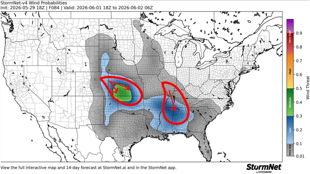
KANSAS CITY, MISSOURI — A potentially significant and rare dual Mesoscale Convective System setup is taking shape for Monday June 1, 2026, with the StormNet-v4 Wind Probabilities model initialized at 18z May 29, 2026 and valid from 18z June 1 through 06z June 2 showing two distinct and intense wind threat zones developing simultaneously — one across the central plains and one across the mid to deep South — with forecasters noting they would not be surprised if one or both systems reach derecho criteria.
StormNet Model Shows Medium to High Wind Threat Across Central Plains MCS Zone
The StormNet-v4 Wind Probabilities map shows the first and most intense of the two circled MCS threat zones positioned across the central plains, with a green medium wind threat core reaching values of 0.5 or higher surrounded by blue low to medium probability shading extending across Kansas, Nebraska, and Missouri. The red circle annotated by forecasters on the map encompasses this central plains MCS zone, with an arrow pointing toward the green core indicating where the highest wind damage probability is concentrated for the Monday event.
This central plains MCS carries the higher wind threat probability of the two systems on the StormNet output and represents the more organized of the dual MCS signals for Monday, though both systems are being taken seriously as potential derecho producers.
Second MCS Threat Zone Circled Across the Mid to Deep South Including Tennessee and Alabama
The second annotated red circle on the StormNet map highlights a separate and distinct blue wind probability zone positioned across the mid to deep South, covering portions of Tennessee, Mississippi, Alabama, and surrounding states. This southern MCS threat carries lower wind probability values than the central plains system but still shows meaningful blue shading indicating a low to medium wind threat across a broad geographic area of the Deep South for Monday evening through overnight.
The simultaneous development of two intense MCS systems across widely separated regions of the country on the same day is an unusual pattern that forecasters are highlighting as worthy of serious attention heading into the Monday timeframe.
Derecho Criteria Possible for One or Both Systems as Pattern Evolves Through Monday
A derecho requires a swath of damaging winds of at least 58 mph extending more than 250 miles, and forecasters are explicitly stating they would not be surprised if one or both of Monday’s MCS events meets this threshold. A derecho event across either the central plains or the Deep South on Monday would represent a significant and potentially destructive wind damage event for millions of residents across the impacted corridors.
Residents across Kansas, Nebraska, Missouri, Tennessee, Mississippi, and Alabama should closely monitor Monday’s severe weather forecasts as this dual MCS setup comes into sharper focus over the coming days.
Stay with GordonRamsayClub.com for the latest updates.

Leave a Reply