
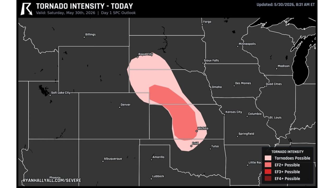
WICHITA, KANSAS — Central Kansas and southern Nebraska are in for a busy and potentially dangerous afternoon on Saturday May 30, 2026, with the Ryan Hall Y’all Tornado Intensity outlook updated at 8:31 AM ET showing a Level 2 tornado threat with EF2 or stronger tornadoes possible across a corridor stretching from the South Dakota border southward through Wichita and into the Enid, Oklahoma area as storms develop with plenty of heat and moisture to work with through the afternoon hours.
EF2 Plus Tornado Zone Covers Central Kansas From South Dakota Border Through Wichita and Enid
The Ryan Hall Y’all Tornado Intensity map valid Saturday May 30, 2026 based on the Day 1 SPC Outlook shows a deep pink EF2 Plus Possible zone covering a broad north-to-south corridor from near the South Dakota and Nebraska border southward through central Nebraska, central Kansas, Wichita, and extending into the Enid, Oklahoma area. This EF2 plus designation indicates that any tornadoes that do develop within this zone have the atmospheric support to reach significant intensity, making them capable of causing substantial structural damage and posing a serious life safety threat to any communities in their direct path.
The lighter pink outer zone indicating general tornado possible coverage extends even further outward, encompassing Rapid City and Sioux Falls to the north and pushing toward Kansas City and Tulsa on the eastern and southern flanks of the overall tornado threat area today.
Storms Will Have Plenty of Heat and Moisture as They Develop This Afternoon
Forecasters specifically note that storms developing across central Kansas and southern Nebraska today will have plenty of heat and moisture available to work with as they fire along the dryline this afternoon, providing the thermodynamic fuel necessary for intense updrafts and supercell organization if wind shear and storm mode cooperate. The combination of robust low-level moisture, elevated instability, and the forcing provided by the negative-tilt trough rotating into the Rockies creates the basic ingredients for a significant severe weather event across this corridor.
The key remaining question continues to be whether individual storms can maintain discrete supercell structure long enough to tap into the better moisture farther east before growing upscale into clusters and lines that would diminish the tornado threat in favor of a damaging wind-dominated event.
Residents From South Dakota Through Kansas and Into Northern Oklahoma Should Be On Alert
The broad geographic scope of today’s tornado intensity outlook means that millions of residents across South Dakota, Nebraska, Kansas, and northern Oklahoma fall within at least the general tornado possible zone for this afternoon and evening. Anyone living within the EF2 plus core zone covering central Kansas and southern Nebraska should treat today’s severe weather threat with the utmost seriousness, have multiple ways to receive tornado warnings, and know their shelter locations before storms arrive.
Stay with GordonRamsayClub.com for the latest updates.

Leave a Reply