
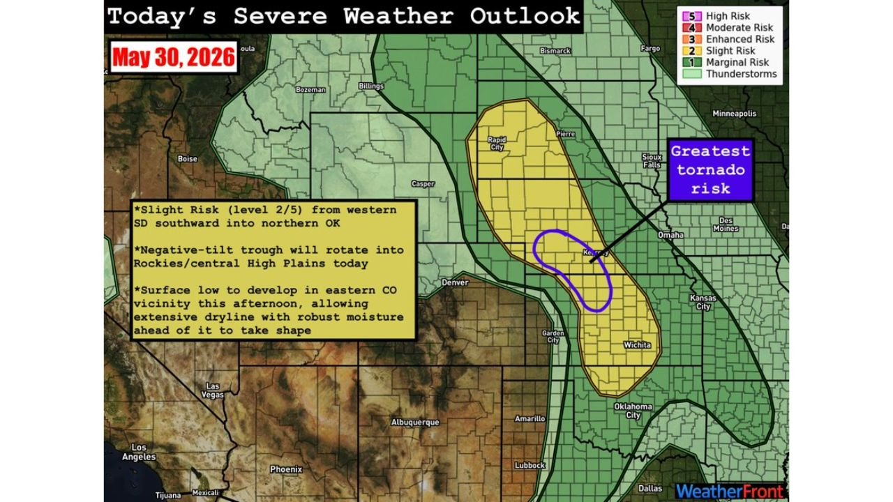
WICHITA, KANSAS — The Storm Prediction Center has outlined a large Slight Risk Level 2 out of 5 severe weather zone stretching from western South Dakota southward through Kansas and into northern Oklahoma for Saturday May 30, 2026, with a negative-tilt trough rotating into the Rockies and central High Plains providing the forcing for storm initiation along an extensive dryline as a surface low develops in eastern Colorado this afternoon.
Greatest Tornado Risk Highlighted Near Kearney Nebraska as Discrete Supercells Possible
The WeatherFront Severe Weather Outlook for May 30, 2026 shows the greatest tornado risk circled in purple directly over the Kearney, Nebraska area, sitting within the broader yellow Slight Risk zone. This region near northeast Colorado, southwest Nebraska, and northwest Kansas represents the best area for discrete supercell development today, where a tongue of robust moisture arcing back into the region combined with southeasterly upslope flow could support organized supercell thunderstorms capable of all hazards including a couple of tornadoes.
However forecasters note that the moisture in this zone is extremely shallow in the vertical, which poses a significant challenge for widespread storm initiation and sustainability. Key questions remain over how quickly storms will grow upscale and how Kansas convection further south may impact the northern regime.
Central Kansas to Northern Oklahoma Seeing Increased Initiation Confidence but Diffuse Dryline
Confidence in storm initiation across central Kansas to northern Oklahoma has increased over the last day, but the dryline in this zone is much more diffuse compared to areas further north. The NAM dewpoint analysis valid at 4:00 PM Saturday shows a sharp moisture gradient across the Garden City corridor where dewpoints drop sharply from 68 degrees near Wichita to just 32 degrees near Garden City, indicating storms initiating here will likely fire into very high temperature-dewpoint spreads and produce ample outflow before entering better moisture to the east.
This outflow-dominant convective mode would lead to quick upscale growth into clusters and lines, decreasing the tornado risk across central Kansas while increasing the damaging wind threat significantly. Should any isolated supercells develop and sustain into the better moisture farther east, an all-hazards risk including tornadoes would exist across that corridor.
Northwest Texas and Southwest Oklahoma Face Conditional Threat With 100 Degree Temperatures
In northwest Texas and southwest Oklahoma, a mix of multicells and a couple of supercells may develop along the dryline, though the setup is more conditional here than areas further north. Surface temperatures approaching 100 degrees Fahrenheit across this zone will lead to very high temperature-dewpoint spreads and outflow-dominant convection, making large hail and damaging winds the greatest threats rather than tornadoes across the southern end of today’s risk area.
Residents across western South Dakota, Nebraska, Kansas, and northern Oklahoma should remain weather-aware through the afternoon and evening and have multiple ways to receive severe weather warnings as today’s complex dryline setup evolves.
Stay with GordonRamsayClub.com for the latest updates.

Leave a Reply