
ATLANTA, GEORGIA — A stormy and dangerous weather pattern is continuing across northern and central Georgia this Sunday, with the threat for strong to severe storms carrying damaging wind gusts and flash flooding expected to intensify through the afternoon and evening hours today.
Severe Threat Level Active Across Atlanta Metro and Surrounding Counties
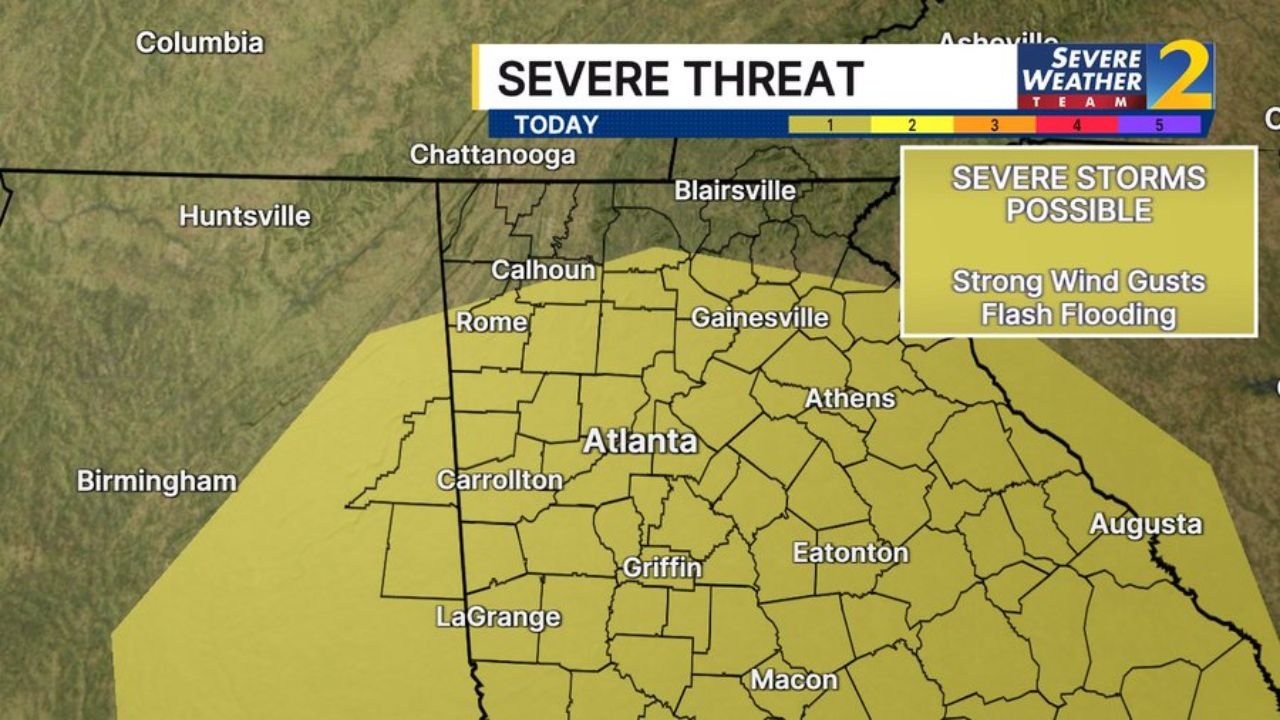
The Severe Weather Team 2 Severe Threat outlook for today has placed a broad severe threat zone covering Atlanta and a wide surrounding area including Rome, Gainesville, Carrollton, Griffin, Eatonton, and Augusta. The yellow threat shading stretches from the Tennessee border in the north down through central Georgia, covering millions of residents within the impacted zone.
The threat scale on the map indicates current conditions sitting at the lower end of the scale, but forecasters are clear that the threat increases as the afternoon and evening hours approach, meaning conditions will deteriorate further through the day.
Damaging Wind Gusts and Flash Flooding Are the Primary Concerns Today
The two headline hazards called out specifically in today’s outlook are strong wind gusts and flash flooding. Storms capable of producing damaging winds have the potential to down trees, knock out power lines, and create dangerous travel conditions across the metro Atlanta region and surrounding counties.
Flash flooding is an additional concern, particularly in low-lying areas and near streams that may already be running elevated from recent rainfall across the region. Residents should avoid flood-prone roads and underpasses if heavy rain begins to fall rapidly.
Huntsville, Chattanooga and Birmingham Also Sitting Within the Threat Zone
The severe threat zone extends well beyond Georgia’s borders. Huntsville, Alabama and Chattanooga, Tennessee are both sitting within the outlined threat area, as is Birmingham, Alabama on the western edge of the map.
This is a multi-state severe weather setup affecting a large and densely populated corridor from northern Alabama and southern Tennessee down through the heart of Georgia.
Residents across all impacted areas should have a weather alert plan ready, stay indoors during the most active storm periods this afternoon and evening, and monitor local forecasts closely throughout the day.
Stay with GordonRamsayClub.com for the latest updates.

Leave a Reply