
NEW ORLEANS, LOUISIANA — The European weather model is maintaining a strong and consistent signal for heavy rainfall and storm activity across a massive stretch of the southern United States through the end of next week, with some of the highest totals on the map concentrated across Louisiana, Mississippi, and the central Gulf Coast region.
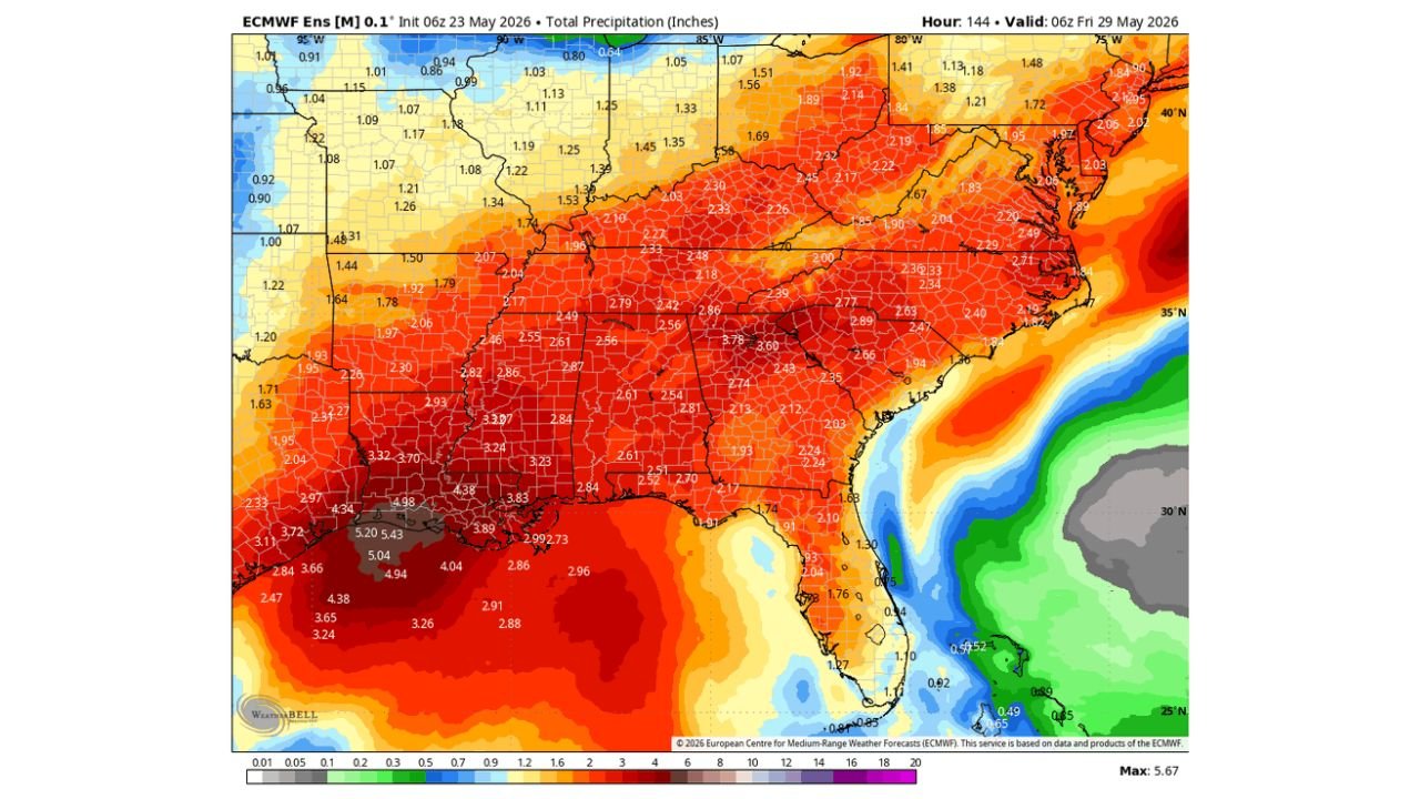
ECMWF Model Shows Up to 5.43 Inches Possible Across Louisiana and Mississippi
The ECMWF Ensemble model, initialized at 06z on May 23, 2026 and valid through 06z Friday May 29, 2026, is projecting total precipitation values reaching as high as 5.43 inches across parts of Louisiana and Mississippi over this period.
Values in the 3 to 5 inch range are widespread across the Deep South, covering large portions of Louisiana, Mississippi, Alabama, and Arkansas. These are significant multi-day accumulations that could lead to flooding concerns in low-lying and flood-prone areas.
Broad 2 to 3 Inch Totals Stretching Across Tennessee, Georgia and the Carolinas
Moving northeast across the map, total precipitation values in the 2 to 3 inch range are projected across much of Tennessee, Georgia, South Carolina, and North Carolina through the same period.
The orange and red shading blankets nearly the entire Southeast, indicating this is not an isolated or localized rain event but rather a broad, region-wide pattern that will affect tens of millions of people through the end of the week.
Northern Plains and Upper Midwest Seeing Much Lighter Totals by Comparison
Across the northern tier of the map, precipitation totals drop considerably. Much of the upper Midwest and Northern Plains is sitting in the 0.80 to 1.25 inch range, shown in lighter blue tones on the model output.
The contrast is stark — while the South is bracing for potentially flooding rainfall, areas farther north are expected to see only modest accumulations over the same timeframe.
With the signal remaining strong and consistent on the ECMWF model, residents across the Gulf Coast and Deep South should monitor forecasts closely and prepare for several more days of heavy rain through Friday May 29.
Stay with GordonRamsayClub.com for the latest updates.

Leave a Reply