
CENTRAL TEXAS — Flash flooding is possible this afternoon and evening across parts of Texas with the highest flood risk concentrated across central Texas, the Hill Country, Big Country, and Concho Valley stretching from Midland and San Angelo southward through Kerrville, Junction, Uvalde, and into the Laredo corridor as multiple rounds of storm activity threaten to produce dangerous and life-threatening flash flooding across the region today.
Forecasters are issuing a clear and urgent warning — never drive into high water under any circumstances regardless of how shallow it may appear.
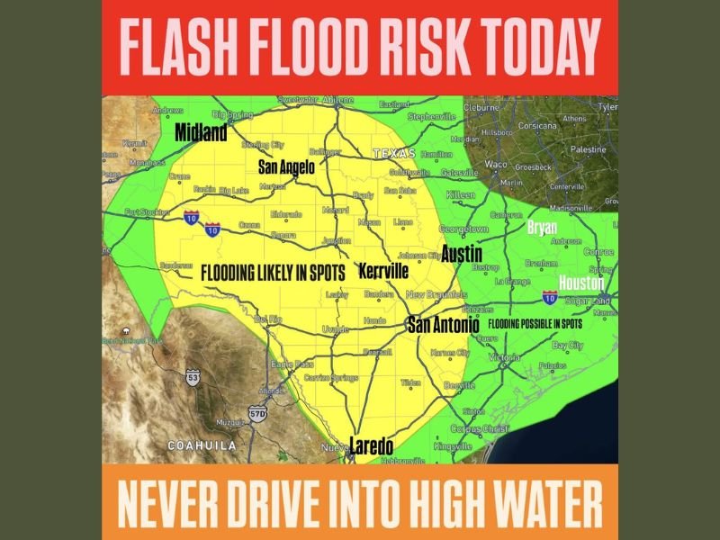
Flooding Likely in Spots Across Yellow Zone Covering Midland San Angelo and Hill Country
The yellow flooding likely zone covers a broad area of central and west Texas stretching from Midland and San Angelo southward through the Concho Valley, Hill Country, and into the Laredo corridor, with communities including Sterling City, Ballinger, Menard, Mason, Kerrville, Junction, Sonora, Eldorado, Ozona, Del Rio, and Uvalde all falling within the highest flash flood risk area today.
The flooding likely designation means organized and repeated rainfall across this zone is expected to produce flash flooding in spots during the afternoon and evening hours, particularly in low-lying areas, dry creek beds, arroyos, and road crossings that can fill rapidly with little warning.
The Hill Country terrain is especially vulnerable to flash flooding due to the rocky and impermeable ground surface that causes rainfall to run off rapidly into creeks and rivers rather than soaking into the soil, creating the potential for sudden and dangerous rises in water levels.
Austin San Antonio and Surrounding Areas Under Flooding Possible in Spots Zone
East of the highest risk yellow zone, a green flooding possible zone extends across Austin, San Antonio, New Braunfels, Bastrop, Georgetown, and surrounding central Texas communities including Bryan and portions of the Houston outer corridor.
While the flooding threat is lower in the green zone compared to the yellow core area, the potential for isolated flash flooding in spots remains real for Austin and San Antonio residents during today’s afternoon and evening storm activity.
Residents across all flood risk zones from Midland and San Angelo through Austin and San Antonio are urged to monitor local flash flood warnings throughout the afternoon and evening and to stay away from flooded roads, creeks, and low-lying areas as dangerous water rises can occur with very little warning.
Stay with GordonRamsayClub.com for the latest updates.

Leave a Reply