
ARKANSAS — The first round of rain in Arkansas’s active weather pattern has delivered 1 to 3 inch amounts across north and parts of west Arkansas over the past three days, with several spots across east and southeast Arkansas also picking up meaningful totals as the wet pattern gets underway across the state.
Over the next 7 to 10 days, most locations across Arkansas will see at least another 1 to 2 inches of rainfall, with south Arkansas potentially seeing 3 or more inches as the heavy rainfall zone becomes better defined closer to the day of each storm event.
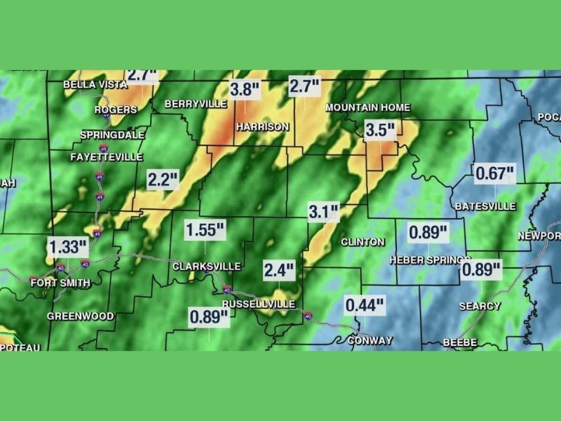
North and West Arkansas Leading With Berryville at 3.8 and Harrison at 3.1 Inches
The highest rainfall totals from the past three days are concentrated across north and northwest Arkansas, with Berryville leading the state at 3.8 inches followed by Mountain Home at 3.5 inches, Harrison at 3.1 inches, and Clarksville at 2.4 inches.
Rogers and Bella Vista picked up 2.7 inches while the Fayetteville and Springdale corridor recorded 2.2 inches over the same three-day period, confirming that the northwest Arkansas communities absorbed the heaviest rainfall from the first active pattern round.
Central Arkansas saw more modest totals with Clinton at 0.89 inches, Russellville at 0.89 inches, Conway at 0.44 inches, and Searcy recording a minimal amount as the rainfall gradient dropped off sharply from north to south across the state.
Another 1 to 2 Inches Minimum Expected Statewide Over Next 7 to 10 Days
Looking ahead through the next 7 to 10 days, forecasters are confident that most Arkansas locations will see at least another 1 to 2 inches of rainfall as the active pattern continues to deliver periodic rounds of rain and storms across the state.
South Arkansas is flagged as the zone most likely to see higher totals in the 3 inch or greater range during the upcoming period, though pinpointing the exact heavy rainfall zone remains difficult until closer to each individual storm event.
The future rain totals map valid Wednesday May 27 shows the heaviest upcoming rainfall focused across south Arkansas and into the Texarkana and Shreveport corridor, with deep orange and red returns indicating significant rainfall accumulations expected across that portion of the state through the extended period. Stay with GordonRamsayClub.com for the latest updates.

Leave a Reply