
WESTERN MICHIGAN — Western Michigan is facing a real and developing tornado risk today May 17 as an MCV moving in from Illinois and Wisconsin interacts with a surface warm front to create higher-end wind shear parameters and low-level helicity suggestive of a strong tornado or two across the western lower Michigan peninsula between 2 PM and 10 PM.
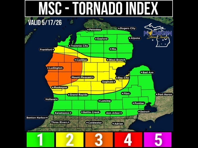
Michigan Storm Chasers have issued a Tornado Index valid May 17 showing an orange Level 4 zone across the highest risk corridor from Frankfort and Muskegon eastward through Cadillac and Big Rapids, with a broad yellow Level 3 zone extending across Grand Rapids, Lansing, Saginaw, Flint, and surrounding communities.
Orange Zone From Frankfort to Muskegon Through Cadillac Carries Best Tornado Potential Today
The orange Level 4 zone covering the western shoreline corridor from Frankfort southward through Muskegon and eastward through Cadillac and Big Rapids represents the area with the best potential for seeing a tornado or two as storms first arrive during the afternoon hours today.
This orange zone has abundant wind shear and spin to support tornado development, with the MCV tracking in from Wisconsin and Illinois expected to further enhance low-level helicity across this corridor as it interacts with the warm frontal zone during the peak severe weather window.
Storm mode this afternoon across the orange zone will likely be supercellular in nature, meaning individual rotating supercell storms rather than a squall line will be the primary tornado producers across the highest risk corridor today.
MCV From Illinois and Wisconsin Tracking Into Western Michigan Enhancing Tornado Setup
Storms currently developing in Illinois and Wisconsin as of late this morning are tied to an MCV — a localized area of low pressure — that will travel into western and northern lower Michigan and interact with the surface warm front during the afternoon hours.
The combination of the incoming MCV and the warm frontal zone will aid in producing higher-end wind shear parameters in both speed and direction, with the resulting low-level helicity providing the spin necessary to support a strong tornado or two across the outlined risk area.
Forecasters note that computer models are not currently capturing this storm development, but real-time observations of developing storms in Wisconsin and Illinois are leading them to lean toward a legitimate tornado risk developing this afternoon despite minimal model guidance supporting it.
Peak Severe Weather Window 2 PM to 10 PM With All Hazards Possible Across Yellow Zone
The main timeframe for any tornadoes and severe weather across Michigan today is focused between 2 PM and 10 PM, covering the entire afternoon and evening period when storm development is expected to be most active across the warm frontal zone and orange risk corridor.
Beyond the tornado threat, a more prominent large hail and damaging wind risk accompanies today’s setup across the broader yellow Level 3 zone covering Grand Rapids, Lansing, Saginaw, Bay City, Flint, Mount Pleasant, and Battle Creek.
Low-end tornado chances extend across the broader yellow zone from Petoskey and Rogers City southward through Kalamazoo and Detroit, meaning residents across most of lower Michigan should remain weather aware between 2 PM and 10 PM today as the severe weather potential unfolds in real time. Stay with GordonRamsayClub.com for the latest updates.

Leave a Reply