
ILLINOIS — Multiple rounds of thunderstorms are expected across Illinois from morning through afternoon and evening on Monday May 18, with damaging wind gusts and hail identified as the main threats throughout the day and a low but not zero embedded tornado threat arriving Monday evening according to the NWS Storm Prediction Center outlook updated at 1:00 AM CDT May 17, 2026.
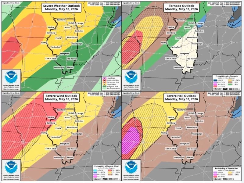
The severe weather outlook valid until 7:00 AM CDT May 19 shows a broad multi-hazard threat covering Illinois from the Enhanced risk in the west through Slight and Marginal risks extending across the eastern portions of the state.
Enhanced and Moderate Risk Covering Western Illinois With Damaging Winds Primary Threat
The severe wind outlook for Monday May 18 shows the highest wind probabilities concentrated across western and central Illinois, with Enhanced and Moderate risk zones covering communities including Galesburg, Moline, Peoria, Springfield, Quincy, and East St. Louis.
Wind probabilities across the core western Illinois zone reach into the 45 to 75 percent range for severe wind gusts, making damaging winds the headline hazard for Monday’s severe weather event across the state.
Dry hours between thunderstorm rounds will provide brief breaks in the action throughout the day, but residents across western and central Illinois should expect multiple periods of dangerous wind-producing storms from the morning hours through the evening.
Severe Hail Threat Concentrated Across Central Illinois With High Probability Core
The severe hail outlook for Monday shows a significant concentration of hail probability across central Illinois, with a striking magenta and pink high-probability core covering portions of the state between Galesburg, Peoria, Bloomington, and Springfield indicating a 45 to 60 percent or greater probability of severe hail within 25 miles.
The intense hail probability zone makes central Illinois one of the most concerning locations for large hail impacts on Monday, with multiple rounds of storms providing repeated opportunities for hail-producing cells to track across the same communities throughout the day.
Chicago, Aurora, DeKalb, Kankakee, and Champaign also fall within the broader hail risk zone, placing the entire northern and central Illinois corridor under a meaningful severe hail threat for Monday’s multi-round storm event.
Low but Not Zero Embedded Tornado Threat Monday Evening Across Northern Illinois
Beyond the wind and hail threats, forecasters are specifically flagging a low but not zero embedded tornado threat for Monday evening across northern Illinois, with the tornado outlook showing a 5 to 14 percent tornado probability across portions of the state including the Chicago, Rockford, DeKalb, and Aurora corridor.
The evening tornado threat is associated with the potential for embedded rotation within the broader storm complex as the system organizes and moves through northern Illinois during the overnight transition period following the day’s multiple storm rounds.
Residents across all of Illinois from Chicago and Rockford in the north through Springfield and Carbondale in the south are urged to have multiple reliable ways to receive severe weather warnings Monday and to remain weather aware from the early morning hours all the way through Monday evening. Stay with GordonRamsayClub.com for the latest updates.

Leave a Reply