
DALLAS, TEXAS — North Texas is heading into an active and stormy stretch beginning Tuesday, with hail, gusty winds, and heavy rain all possible as a front moves into the region breaking down the remaining cap and allowing numerous showers and thunderstorms to develop through the afternoon and evening hours across the Dallas, Fort Worth, and Wichita Falls corridor.
Rain chances are expected to continue through the rest of the week and into Memorial Day weekend, with the second half of May looking much wetter than average across Texas.
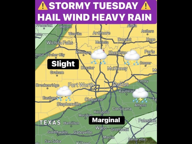
Slight Risk Covers Dallas Fort Worth Corridor Tuesday With Hail and Gusty Winds Possible
A Slight risk zone is in place across the Dallas and Fort Worth metroplex corridor for Tuesday, with a Marginal risk extending southward toward Waco and surrounding areas as the front pushes into North Texas during the afternoon and evening hours.
A few stronger storms developing Tuesday afternoon and evening may contain hail and gusty winds as the front helps break down any remaining cap across the region and allows storm activity to become more numerous through the day.
The muggy air already moving into the region with dewpoints now in the 70s is providing abundant moisture to fuel storm development once the front arrives and begins lifting the cap during the Tuesday afternoon hours.
Monday Brings Dryline Closer to Metroplex With Collapsing Storm Wind Threat After 5 PM
Before Tuesday’s more organized storm threat arrives, Monday presents its own localized wind concern as the dryline shifts closer to the metroplex and provides additional lift after 5 PM across the Dallas and Fort Worth area.
A few storms may develop Monday afternoon and evening, with any collapsing storms capable of once again sending strong outflow winds to the surface as very dry air aloft causes storm cells to collapse quickly after development.
The Monday storm threat is less organized than Tuesday’s setup but still warrants awareness from residents across the metroplex who may be outdoors during the late afternoon and early evening hours.
Heavy Rain Threat Increases Tuesday Night Into Wednesday With Front Slowing Over North Texas
The most significant rainfall potential of the entire multi-day event arrives Tuesday night into Wednesday morning as the front slows its forward progress and moves through the area at a reduced pace, increasing the potential for heavy and prolonged rainfall across North Texas.
By Wednesday the front should be south of the metroplex, setting up an overrunning pattern that will generate additional showers and thunderstorms across North Texas throughout the day as moisture continues streaming northward over the frontal boundary.
Rain chances are forecast to persist through the remainder of the week and into Memorial Day weekend, making the second half of May a significantly wetter period than average for Texas residents from the Dallas and Fort Worth metroplex southward through Waco and surrounding communities. Stay with GordonRamsayClub.com for the latest updates.

Leave a Reply