
ATLANTA, GEORGIA — Scattered storms are set to develop this Sunday afternoon into evening across metro Atlanta and north Georgia, with the strongest storms capable of producing wind gusts up to 60 MPH and nickel to quarter size hail across communities including Atlanta, Rome, Gainesville, Calhoun, Athens, Carrollton, and Griffin.
Severe Weather Team 2 has outlined a broad severe threat zone covering north Georgia while also highlighting a significantly more dangerous severe weather setup unfolding well to the northwest across the Plains and Midwest today.
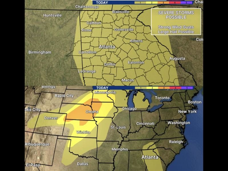
Strongest Storms Capable of 60 MPH Gusts and Quarter Size Hail Across Metro Atlanta
The severe threat across metro Atlanta and north Georgia today carries the potential for strong wind gusts reaching up to 60 MPH and large hail ranging from nickel to quarter size in the strongest individual storm cells that develop during the afternoon and evening hours.
The outlined threat zone covers a wide swath of north Georgia stretching from Chattanooga and Huntsville in the north through Rome, Calhoun, Gainesville, and Athens across the middle tier and southward through Atlanta, Carrollton, Griffin, Eatonton, and Augusta.
Scattered development means not every location across north Georgia will see severe weather today, but any storm that does strengthen has the potential to produce dangerous wind gusts and large hail before moving through the area.
Severe Threat Zone Covers Broad North Georgia Corridor Sunday Afternoon
The Severe Weather Team 2 outlook places the entire north Georgia corridor under a Level 1 to 2 severe threat today, with the yellow shading covering communities from the Tennessee border southward through the Atlanta metro and into the Augusta and Macon areas.
Residents across Rome, Gainesville, Blairsville, Athens, Carrollton, LaGrange, and surrounding north Georgia communities should remain weather aware throughout the afternoon and evening and be prepared to take shelter quickly if a severe storm approaches their location.
Outdoor activities and events scheduled across metro Atlanta and north Georgia this Sunday afternoon should be approached with caution given the scattered severe storm potential that will develop during the peak afternoon heating hours.
More Significant Severe Threat Ongoing to the Northwest Across Plains and Midwest
While north Georgia faces a scattered severe threat today, forecasters are noting that a significantly more dangerous and impactful severe weather setup is ongoing well to the northwest across the Central Plains and Midwest.
The wider picture shows an enhanced orange and yellow severe threat zone covering a large area from Denver and Wichita through Omaha and into the Minneapolis corridor, representing a much higher-end severe weather event compared to the scattered activity expected across north Georgia today.
Residents across both the Atlanta metro area and the broader northwest severe threat corridor from Kansas through Minnesota are urged to stay weather aware throughout Sunday and monitor updates as the dual severe weather setups continue to evolve during the afternoon and evening hours. Stay with GordonRamsayClub.com for the latest updates.

Leave a Reply