
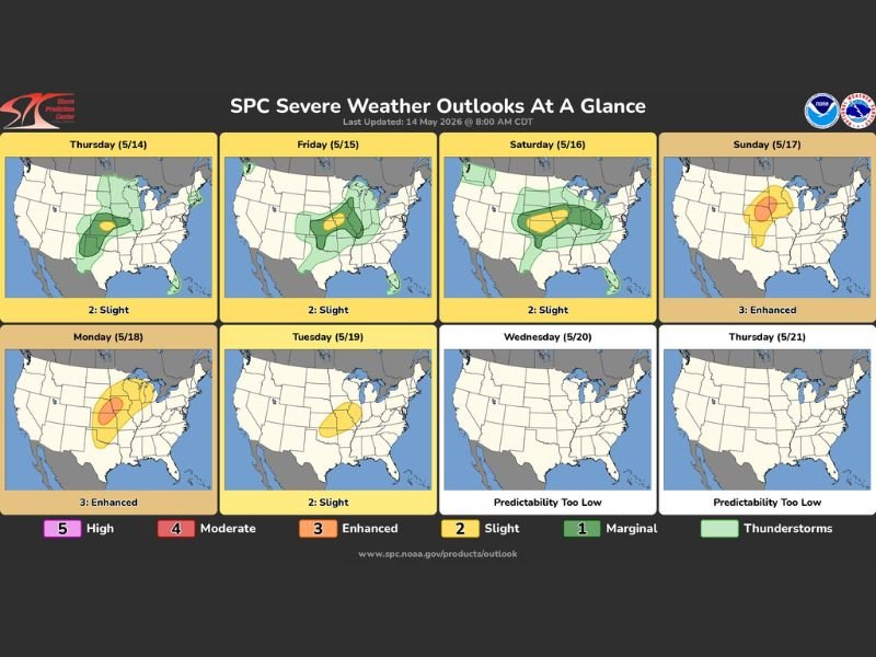
CENTRAL PLAINS — An active and prolonged severe thunderstorm pattern is now underway across portions of the Plains to the Mid and Upper Mississippi Valley, with multiple days of severe storms expected from today Thursday May 14 all the way through Tuesday May 19, according to the Storm Prediction Center’s latest severe weather outlook updated at 8:00 AM CDT on May 14, 2026.
Sunday May 17 and Monday May 18 stand out as the most dangerous days of the entire six-day stretch, both carrying an Enhanced Level 3 risk designation across the affected corridor.
Thursday Through Saturday Bring Slight Level 2 Risk Across Central Plains
The severe weather pattern kicks off today Thursday May 14 with a Slight Level 2 risk across portions of the Central Plains, with the same Slight risk continuing through Friday May 15 and Saturday May 16 as the active pattern maintains its grip on the region.
The Slight risk days Thursday through Saturday are not without hazard, as organized severe storms remain possible across the Central Plains and into portions of the Mississippi Valley during this three-day opening stretch of the pattern.
Friday and Saturday show the Slight risk zone shifting and expanding slightly eastward compared to Thursday, signaling the gradual progression of the severe weather threat across the region as the pattern evolves through the week.
Sunday May 17 Upgrades to Enhanced Level 3 Risk Across Upper Mississippi Valley
The severe weather threat takes a significant step up on Sunday May 17 with an upgrade to an Enhanced Level 3 risk across the Upper Mississippi Valley corridor, placing the day in a notably more dangerous category than the Slight risk days that precede it.
Sunday’s Enhanced risk zone is concentrated across the Upper Midwest and Upper Mississippi Valley region, with the orange Enhanced designation indicating a higher probability of significant and organized severe weather activity compared to the earlier days in the pattern.
Residents across the Upper Mississippi Valley and surrounding states should treat Sunday as a high-priority severe weather awareness day given the Enhanced Level 3 designation and the potential for dangerous storm activity.
Monday May 18 Carries Second Consecutive Enhanced Level 3 Risk as Pattern Peaks
Monday May 18 delivers a second consecutive Enhanced Level 3 risk day, making Sunday and Monday back-to-back dangerous severe weather days across the Plains and Mississippi Valley corridor during the peak of the multi-day active pattern.
Monday’s Enhanced risk zone shows a large orange area covering a broad swath of the Central Plains and surrounding states, with the intensity and geographic coverage of the threat reflecting the most significant severe weather setup of the entire six-day stretch.
Tuesday May 19 steps back down to a Slight Level 2 risk before predictability drops too low to issue specific outlooks for Wednesday May 20 and Thursday May 21, meaning the active pattern gradually winds down after Tuesday while residents remain weather aware through the end of next week. Stay with GordonRamsayClub.com for the latest updates.

Leave a Reply