
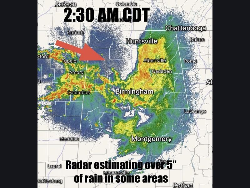
NORTHWEST ALABAMA / BIRMINGHAM — A 3 a.m. First Alert Weather Day update confirmed that severe storms that swept through Marion, Lamar, northern Tuscaloosa, Jefferson, and southern Blount counties have now weakened — but radar is estimating over 5 inches of rain in parts of northwest Alabama, localized flooding is becoming a growing concern, and another increase in storms is expected by Wednesday evening especially across southern Alabama.
Severe Storms Move Through Marion Lamar Tuscaloosa and Jefferson Counties
Earlier in the overnight hours, forecasters were actively tracking severe storms that originated in Marion and Lamar counties before pushing into northern Tuscaloosa, Jefferson, and southern Blount counties. Those storms produced gusty winds significant enough to down trees in at least one confirmed location — the Winfield area — with forecasters warning that additional downed limbs and debris on roadways remain a real hazard across the affected corridor in the dark early morning hours.
Drivers on roads across northwest Alabama through the early morning were urged to remain alert for debris, downed limbs, and standing water on roadways given the heavy overnight rainfall totals already accumulated.
Radar Estimating Over 5 Inches of Rain in Northwest Alabama
The most significant and developing concern at 3 a.m. is the extraordinary rainfall accumulation radar is detecting across parts of northwest Alabama. Radar estimates are showing over 5 inches of rain in some areas — a total that is more than sufficient to trigger localized flooding, overwhelm drainage systems, and produce dangerous conditions on roadways and in low-lying areas.
With more storms continuing to move in from the northwest at the time of the 2:30 a.m. CDT radar snapshot, additional rainfall accumulation on top of already saturated ground is pushing localized flooding from a concern into an increasingly likely outcome for vulnerable areas across the northwest Alabama corridor.
Storms Below Severe Levels But Heavy Rain and Thunder Continuing
While the storm complex had dropped below severe thunderstorm warning thresholds by 3 a.m., forecasters were clear that conditions remain dangerous in a different way. Heavy rain is still pouring across many areas with occasional thunder, and the ongoing train of rainfall is expected to continue through the early morning hours before gradually tapering to spotty showers.
The distinction between severe and non-severe storms matters for wind and hail risk — but does not reduce the flooding threat when rainfall totals are already at 5-inch levels across the region.
Another Round of Storms Expected Wednesday Evening — Especially South
The overnight storm activity is not the end of Alabama’s weather story for Wednesday. Forecasters confirmed that another increase in rain and storms is expected by Wednesday evening — with the southern half of Alabama facing the most significant threat from the evening round.
Communities across central and south Alabama including Montgomery, Dothan, Troy, Monroeville, and surrounding areas should monitor Wednesday afternoon and evening conditions closely as the next round of storm activity develops.
Live updates were scheduled to resume with meteorologist Meaghan beginning at 4 a.m. for the latest radar tracking and storm progression across the state. Stay with GordonRamsayClub.com for the latest updates.

Leave a Reply