
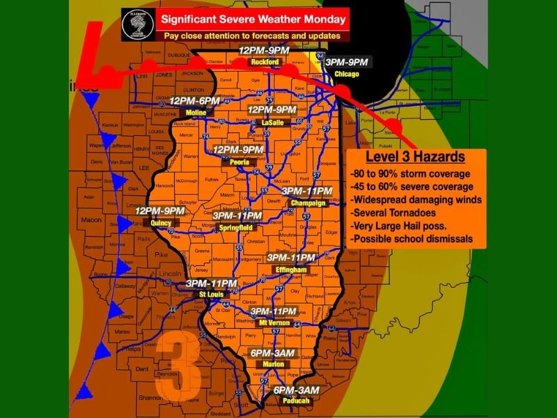
SPRINGFIELD, ILLINOIS — Monday was shaping up to be a significant severe weather day across Illinois, with a powerful storm system bringing a warm, moist, and very unstable environment that would ignite storms across the state. Level 3 Hazards were in place covering 80 to 90 percent storm coverage, 45 to 60 percent severe coverage, widespread damaging winds up to 80 mph, several tornadoes, and very large hail possible. Possible school dismissals were also flagged as a concern given the severity and timing of the event running from noon through 11 PM across most of the state.
Discrete Supercells First With Strong Tornadoes — Then Widespread Damaging Winds Up to 80 MPH
Storms were expected to initially develop as discrete supercells favored in western Illinois, carrying all hazards including strong tornadoes during the early afternoon window. The storms would then quickly grow upscale into a line of severe thunderstorms racing east through the state, at which point widespread damaging winds up to 80 mph and embedded tornadoes would become the dominant threats for communities across central and eastern Illinois.
The rapid transition from discrete supercells to a squall line meant the tornado threat would be highest in the early portion of the event across western Illinois before shifting to a damaging wind threat as the line organized and raced eastward.
Timing Breakdown Across Illinois — Noon to 11 PM Coverage Statewide
The timing of the severe weather varied by location across the state. The noon to 9 PM window covered Rockford, Moline, LaSalle, and Peoria in the north and central zones. Springfield, Champaign, Quincy, and St. Louis fell into the 3 PM to 11 PM window, while Effingham and Mt. Vernon were also in the 3 PM to 11 PM range. Southern communities including Marion and Paducah faced the latest timing at 6 PM through 3 AM, indicating an overnight severe weather threat for the southernmost portions of the region.
School Dismissals Possible — Residents Urged to Prepare and Monitor Updates
Given the severity of the Monday setup, possible school dismissals were flagged as a real concern across the affected zones, with officials and forecasters urging early preparation and awareness. Residents across all of Illinois were urged to prepare, have a way to receive warnings, and monitor forecasts closely throughout the day as the significant severe weather event developed from noon onward across the state. Stay with GordonRamsayClub.com for the latest weather updates and detailed forecast coverage.

Leave a Reply