
LITTLE ROCK, ARKANSAS — Tuesday was bringing a little bit of everything across Arkansas, with warm temperatures, gusty winds topping 20 mph, variable cloud cover, and low-end rain chances combining for a mixed but generally pleasant day. High temperatures ranged from the upper 60s in western Arkansas to the low 80s in the eastern portion of the state, with forecasters also keeping a close eye on the potential for stronger thunderstorms developing later in the week around Friday.
Warm Tuesday Highs Ranging From 67 to 81 Across Arkansas
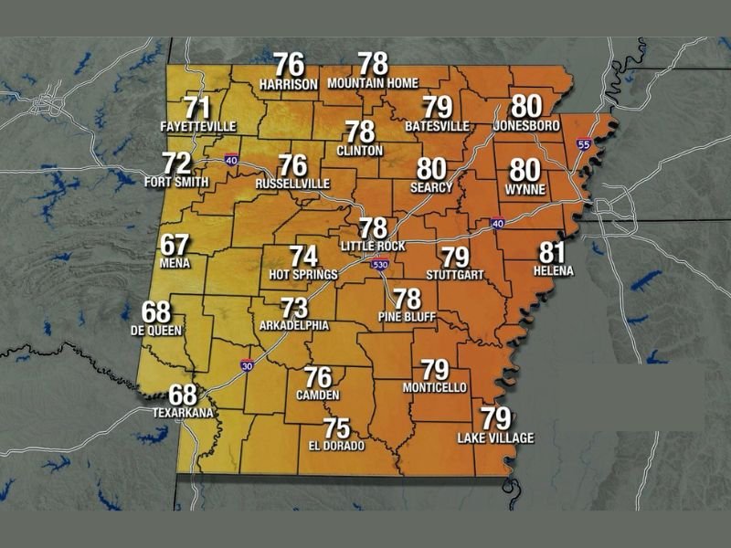
The high temperature map for Tuesday showed a clear west to east warming gradient across Arkansas. Western communities ran cooler, with Mena at 67, De Queen and Texarkana at 68, Fort Smith at 72, and Fayetteville at 71. Central Arkansas held in the mid to upper 70s, with Little Rock at 78, Russellville at 76, and Hot Springs at 74.
Eastern Arkansas ran warmest on Tuesday, with Helena leading the state at 81 degrees, followed by Jonesboro and Wynne both at 80, Stuttgart at 79, and Searcy also hitting 80. The warmer readings east of Little Rock aligned with the forecast that eastern portions of the state would see more sunshine and less cloud interference through the day.
Clouds and Low Rain Chances Across Western Arkansas — Windier Than Yesterday
Cloud cover was expected to be more prevalent across western Arkansas on Tuesday, bringing low-end rain chances to communities in that portion of the state. The cloud coverage was not expected to produce significant or impactful rainfall, keeping the rain threat at a low level for western communities through the day.
Tuesday was also forecast to be windier than Monday statewide, with gusts exceeding 20 mph possible across Arkansas through the day. The added wind combined with the variable cloud cover and temperature spread gave Tuesday a notably mixed weather character compared to recent days.
Stronger Thunderstorms Being Watched for Friday
Looking ahead, forecasters were actively monitoring the potential for stronger thunderstorm development later in the week, with Friday identified as the most likely timeframe for any more significant severe weather activity across Arkansas. The exact nature and intensity of the Friday storm threat was still being evaluated, with further details expected to be released as the week progressed and confidence in the forecast increased. Stay with GordonRamsayClub.com for the latest weather updates and detailed forecast coverage.

Leave a Reply