
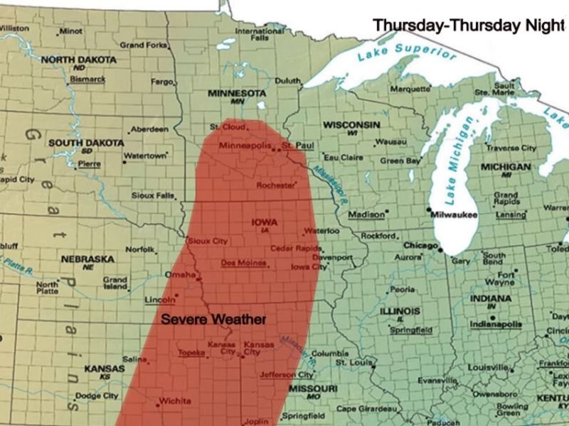
MINNEAPOLIS, MINNESOTA — Severe weather was increasingly likely Thursday afternoon and evening across a corridor stretching from central Minnesota down through Iowa and into eastern Kansas and western Missouri. Environmental conditions were expected to support strong tornadoes, very large hail, and damaging winds, with supercells possible initially before the storm mode transitioned into a squall line. Severe thunderstorms were expected to weaken once they reached the Mississippi River.
Supercells Developing First — Supporting Strong Tornadoes and Very Large Hail
Forecasters indicated that wind profiles were expected to be parallel to the surface boundary heading into Thursday, making convection initially sloppy. Despite the messy setup, supercells were forecast to develop in the early stages of the event before growing upscale into a squall line.
During the supercell phase, environmental conditions were expected to support strong tornadoes and very large hail all the way up through central Minnesota. The Minneapolis and St. Paul area, Rochester, and the broader central Minnesota corridor were all within the zone where supercell activity and the associated tornado and large hail threat were considered increasingly likely during Thursday afternoon.
Damaging Winds and Embedded Tornadoes Main Concern as Storms Grow Upscale
Once the initial supercells grew upscale and transitioned into a squall line or linear mode, the primary threats were expected to shift toward damaging winds and embedded tornadoes. This transition was a critical part of the forecast, as the squall line phase typically brought widespread wind damage potential across a broader area compared to the more localized but intense supercell phase earlier in the event.
The threat corridor covered a significant north-to-south zone on the risk map, with the shaded severe weather area running from central Minnesota through the Twin Cities, down through Iowa including Des Moines and Cedar Rapids, and continuing into eastern Kansas through Topeka and into western Missouri including Kansas City and Jefferson City.
Severe Thunderstorms Expected to Weaken at the Mississippi River
One notable aspect of the Thursday forecast was the anticipated weakening trend once the severe thunderstorms reached the Mississippi River. Forecasters specifically noted that storms were expected to lose intensity upon reaching that boundary, providing some guidance on where the most significant severe weather impacts would be concentrated heading into Thursday night.
Residents across the entire risk corridor from central Minnesota through Iowa and into eastern Kansas and western Missouri were advised to remain weather aware throughout Thursday afternoon and evening. Stay with GordonRamsayClub.com for the latest weather updates and detailed forecast coverage.

Leave a Reply