
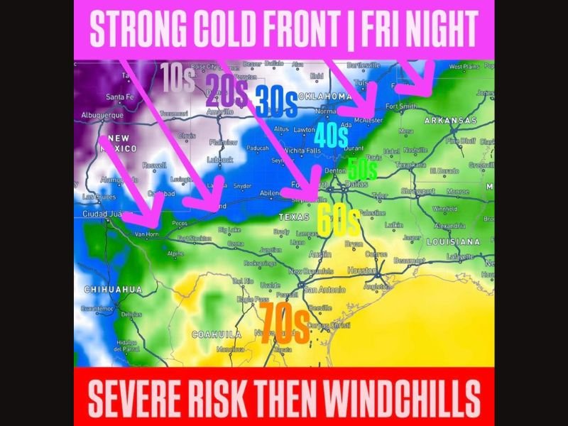
TEXAS AND OKLAHOMA — A strong cold front moving through overnight Friday into Saturday will spark a final round of severe storms for the week before quickly dropping temperatures across the region, with windchills falling to the 40s across northwest Texas, 30s across central, western, and northern Oklahoma, and 20s in the Panhandles by Friday night into Saturday morning, as a frost and freeze become possible Friday night in the Panhandles with frost potentially reaching as far south as I-44 by Saturday night.
Strong Cold Front Arriving Overnight Friday Brings Final Severe Storm Round for the Week
The active severe weather pattern that has dominated the region this week is set to come to a temporary close with the arrival of a strong cold front overnight Friday into Saturday. Before the front fully pushes through, it will trigger a final round of severe storms as the leading edge of the system moves across the area.
The front will bring with it quickly falling temperatures and increasingly stable air in its wake, effectively shutting down the severe weather threat once it passes. This final round of storms associated with the frontal passage represents the closing chapter of a busy severe weather week for Texas and Oklahoma residents before conditions shift dramatically behind the system.
Windchills Drop to 40s in Northwest Texas and 30s Across Central and Northern Oklahoma
The temperature drop behind the cold front will be rapid and significant. By Friday night into Saturday morning, windchill values across northwest Texas are forecast to fall into the 40s as the cold air surges southward behind the frontal boundary.
Conditions will be even colder further north, with central, western, and northern Oklahoma expected to see windchills drop into the 30s. The combination of falling temperatures and gusty winds behind the front will make conditions feel considerably colder than the actual air temperature across a broad swath of the region during the overnight and early morning hours following frontal passage.
Panhandles Face Windchills in the 20s With Frost and Freeze Possible Friday Night
The coldest conditions behind the front will be felt across the Panhandles of both Texas and Oklahoma, where windchills are forecast to drop into the 20s by Friday night into Saturday morning. The sharp drop into the 20s in the Panhandles represents a dramatic temperature swing from the warm and storm-capable air ahead of the front.
A frost and freeze are both possible in the Panhandles on Friday night as temperatures plunge behind the cold front. Residents and agricultural interests in the Panhandle region should take precautions ahead of the possible freeze, as the combination of cold air, clear skies, and light winds behind the front will create favorable conditions for frost development overnight.
Frost Possibly Reaching as Far South as I-44 Corridor by Saturday Night
The reach of the cold air does not stop at the Panhandles. Forecasters indicate that frost could extend as far south as the I-44 corridor by Saturday night, meaning a significantly broader area of Oklahoma could experience frost conditions as the cold air settles more deeply into the region into the weekend.
The progression of the frost threat southward toward I-44 by Saturday night is an important signal for residents across a wide area of Oklahoma to monitor as the weekend approaches. Anyone with sensitive plants, crops, or outdoor concerns should watch the evolving forecast closely as the cold front moves through and temperatures fall sharply across Texas and Oklahoma in the days ahead. Stay with GordonRamsayClub.com for the latest weather updates and detailed forecast coverage.

Leave a Reply