
PENNSYLVANIA — What should feel like a mild and festive Easter Sunday across Pennsylvania is instead turning into a damp and unsettled weather day, as a cold front pushes through the state bringing widespread showers, cloudy skies, and noticeably cooler air.
From morning through the afternoon, much of the state is expected to remain under periods of rain, with only brief breaks possible later in the day. While severe weather is not expected, the shifting pattern signals a much bigger cooldown arriving early next week.
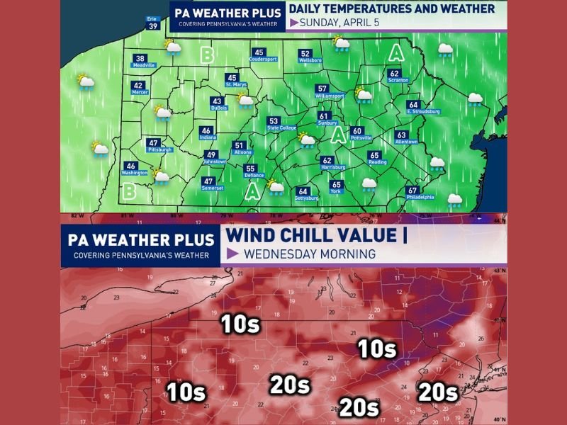
Showers Move Across the State Throughout Sunday
The cold front moving across Pennsylvania is driving ongoing rain from west to east, keeping conditions wet for much of the day. Western parts of the state are expected to see additional rounds of showers developing later in the afternoon, while central and eastern areas deal with steady rain through midday.
Temperatures will vary significantly depending on location, ranging from the low 40s in western Pennsylvania to the mid and upper 60s in eastern regions, creating a noticeable temperature contrast across the state. In far eastern Pennsylvania, there is also a slight chance of thunder, though storms are expected to remain isolated and weak.
Two Weather Zones Shape the Day
Forecasters are dividing the state into two main zones based on conditions:
Area A (Central and Eastern Pennsylvania):
Rain showers will dominate through the morning and early afternoon, with occasional breaks possible later in the day. Skies may turn partly cloudy toward evening, offering some limited improvement after a gray start.
Area B (Western and Northern Pennsylvania):
Morning showers and mostly cloudy skies will give way to additional hit-or-miss rain showers in the afternoon. In colder pockets, especially north of Interstate 80, some showers may even mix with snow pellets, although no accumulation or significant impacts are expected.
Brief Improvements Before a Major Temperature Drop
While Sunday remains cool and damp, conditions are not expected to be severe. However, this system is just the beginning of a much more dramatic shift in weather expected early in the week.
By Tuesday into Tuesday night, a surge of colder air will sweep into Pennsylvania, bringing a sharp drop in temperatures and a return to winter-like conditions.
Midweek Brings Shock Cold With Wind Chills in the 10s
The most significant change arrives by Wednesday morning, when wind chill values across much of Pennsylvania are expected to fall into the 10s and 20s — a stark contrast to the milder conditions seen recently.
Some areas, particularly north of I-80, could even see scattered snow showers on Tuesday, reinforcing the abrupt return of cold air.
Gradual Warm-Up Returns Later in the Week
After the midweek chill, temperatures are expected to recover quickly, with a warming trend returning by the end of the week. This rebound should bring more seasonable spring conditions back to the region.
A Damp Easter With a Winter Reminder Ahead
While Easter Sunday won’t bring severe weather, it will be marked by persistent rain, cloudy skies, and cooler temperatures across Pennsylvania. More importantly, it serves as a transition point into a much colder pattern that could catch many off guard heading into the middle of the week. Stay tuned for further updates as this changing weather pattern continues to develop.

Leave a Reply